IMAGES TAKEN NEAR TO
Park Drive, LONDON, N21 2LU
Introduction
This page details the photographs taken nearby to Park Drive, N21 2LU by members of the Geograph project.
The Geograph project started in 2005 with the aim of publishing, organising and preserving representative images for every square kilometre of Great Britain, Ireland and the Isle of Man.

There are currently over 7.5m images from over14,400 individuals and you can help contribute to the project by visiting https://www.geograph.org.uk
Image Map
Images are licensed for reuse under creativecommons.org/licenses/by-sa/2.0
Notes
- Clicking on the map will re-center to the selected point.
- The higher the marker number, the further away the image location is from the centre of the postcode.
Image Listing (131 Images Found)
Images are licensed for reuse under creativecommons.org/licenses/by-sa/2.0
Image
Details
Distance
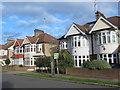
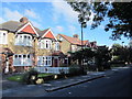
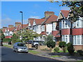
2
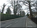
Park Drive
View WNW along Park Drive.
Image: © David P Howard
Taken: 24 Jul 2014
0.03 miles
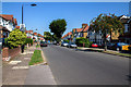
5
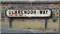
Old sign for Clarendon Way, N21
Image: © Mike Quinn
Taken: 14 Oct 2015
0.05 miles
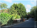
8
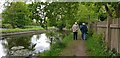
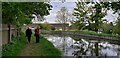
New River Footpath, Bush Hill
Part of the New River footpath, owned by Thames Water.
Image: © Christine Matthews
Taken: 11 May 2021
0.08 miles
9
New River Footpath, Bush Hill
Part of the New River footpath, owned by Thames Water.
Image: © Christine Matthews
Taken: 11 May 2021
0.08 miles
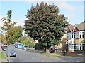
10
Bush Hill looking towards Green Dragon Lane Junction.
Bush Hill looking towards Green Dragon Lane with the New River on the left.
Image: © Christine Matthews
Taken: 18 Feb 2007
0.08 miles