IMAGES TAKEN NEAR TO
Grange Park Avenue, LONDON, N21 2LJ
Introduction
This page details the photographs taken nearby to Grange Park Avenue, N21 2LJ by members of the Geograph project.
The Geograph project started in 2005 with the aim of publishing, organising and preserving representative images for every square kilometre of Great Britain, Ireland and the Isle of Man.

There are currently over 7.5m images from over14,400 individuals and you can help contribute to the project by visiting https://www.geograph.org.uk
Image Map (Loading...)


Getting Data...Please wait
Leaflet Map data © OpenStreetMap
Images are licensed for reuse under creativecommons.org/licenses/by-sa/2.0
Notes
- Clicking on the map will re-center to the selected point.
- The higher the marker number, the further away the image location is from the centre of the postcode.
Image Listing (129 Images Found)
Images are licensed for reuse under creativecommons.org/licenses/by-sa/2.0
Image
Details
Distance

2
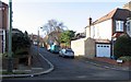
Crossway, London N21
Crossway viewed from Park Drive. This road does not having any houses in it!
Image: © John Salmon
Taken: 1 Jan 2007
0.05 miles
4
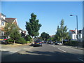
Park Drive
View WNW along Park Drive.
Image: © David P Howard
Taken: 24 Jul 2014
0.07 miles


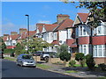
9
Bush Hill looking towards Green Dragon Lane Junction.
Bush Hill looking towards Green Dragon Lane with the New River on the left.
Image: © Christine Matthews
Taken: 18 Feb 2007
0.08 miles