IMAGES TAKEN NEAR TO
The Orchard, LONDON, N21 2DN
Introduction
This page details the photographs taken nearby to The Orchard, N21 2DN by members of the Geograph project.
The Geograph project started in 2005 with the aim of publishing, organising and preserving representative images for every square kilometre of Great Britain, Ireland and the Isle of Man.

There are currently over 7.5m images from over14,400 individuals and you can help contribute to the project by visiting https://www.geograph.org.uk
Image Map (Loading...)


Getting Data...Please wait
Leaflet Map data © OpenStreetMap
Images are licensed for reuse under creativecommons.org/licenses/by-sa/2.0
Notes
- Clicking on the map will re-center to the selected point.
- The higher the marker number, the further away the image location is from the centre of the postcode.
Image Listing (144 Images Found)
Images are licensed for reuse under creativecommons.org/licenses/by-sa/2.0
Image
Details
Distance
1
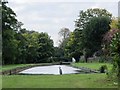
The New River south of Walnut Grove, EN1
See Image
Originally, the course of the New River approached this point from the right (northwest) having followed a wide loop around Enfield. In the mid-1920s, three lines of pipes were laid in the three quarters of a mile between Southbury Road - see Image - and where the heron is standing in the photo. A small flow of water is supplied to the old loop for amenity purposes.
Image: © Mike Quinn
Taken: 14 Oct 2015
0.05 miles

4
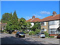
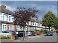
Faversham Avenue, EN1
The New River runs behind these houses.
Image: © Mike Quinn
Taken: 14 Oct 2015
0.08 miles
5
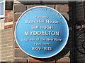
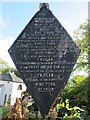
Blue plaque near the flats in Cunard Crescent, N21
See Image
Image: © Mike Quinn
Taken: 14 Oct 2015
0.09 miles
6
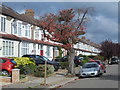
Faversham Avenue, EN1 (2)
The west side, north of Teynham Avenue. The New River runs behind these houses.
Image: © Mike Quinn
Taken: 14 Oct 2015
0.09 miles
7
Late 18th century sluice, New River, Bush Hill
Grade II listed structure described at this http://www.imagesofengland.org.uk/Details/default.aspx?pid=2&id=200829
Image: © Jim Osley
Taken: 1 Jul 2012
0.09 miles
8
Old MWB sign by the bridge over the New River, Bush Hill Road, N21
Image: © Mike Quinn
Taken: 14 Oct 2015
0.09 miles
9
Bridge over the New River, Bush Hill Road, N21
Image: © Mike Quinn
Taken: 14 Oct 2015
0.09 miles
10
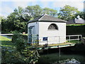
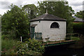
Sluice House on the New River just north of Bush Hill Road, N21
See Image The gates of this late 18th C (1796) sluice house were operated to control the flow of water over the Bush Hill frame - see Image The building is Grade II listed http://www.historicengland.org.uk/listing/the-list/list-entry/1260895 .
Image: © Mike Quinn
Taken: 14 Oct 2015
0.09 miles