IMAGES TAKEN NEAR TO
Green Lanes, LONDON, N21 2BH
Introduction
This page details the photographs taken nearby to Green Lanes, N21 2BH by members of the Geograph project.
The Geograph project started in 2005 with the aim of publishing, organising and preserving representative images for every square kilometre of Great Britain, Ireland and the Isle of Man.

There are currently over 7.5m images from over14,400 individuals and you can help contribute to the project by visiting https://www.geograph.org.uk
Image Map
Images are licensed for reuse under creativecommons.org/licenses/by-sa/2.0
Notes
- Clicking on the map will re-center to the selected point.
- The higher the marker number, the further away the image location is from the centre of the postcode.
Image Listing (148 Images Found)
Images are licensed for reuse under creativecommons.org/licenses/by-sa/2.0
Image
Details
Distance
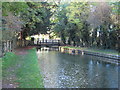
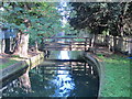
3
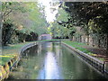
The New River north of Ford's Grove, N21 (3)
Image: © Mike Quinn
Taken: 14 Oct 2015
0.02 miles
4
The New River north of Ford's Grove, N21 (4)
See Image
Image: © Mike Quinn
Taken: 14 Oct 2015
0.02 miles
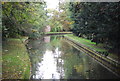
5
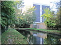
The New River west of The Paulin Ground (2)
See Image
Image: © Mike Quinn
Taken: 14 Oct 2015
0.03 miles
7
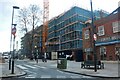
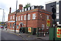
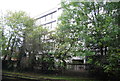
Building works on Green Lanes, Winchmore Hill
The old office block is being converted into flats as it no longer requires planning permission.
Image: © David Howard
Taken: 17 Mar 2021
0.04 miles
8
The New River north of Ford's Grove, N21
See Image
Image: © Mike Quinn
Taken: 14 Oct 2015
0.04 miles
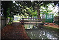
9
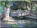
Footbridge over the New River north of Ford's Grove, N21
See Image
Image: © Mike Quinn
Taken: 14 Oct 2015
0.04 miles