IMAGES TAKEN NEAR TO
Uplands Way, LONDON, N21 1DT
Introduction
This page details the photographs taken nearby to Uplands Way, N21 1DT by members of the Geograph project.
The Geograph project started in 2005 with the aim of publishing, organising and preserving representative images for every square kilometre of Great Britain, Ireland and the Isle of Man.

There are currently over 7.5m images from over14,400 individuals and you can help contribute to the project by visiting https://www.geograph.org.uk
Image Map
Images are licensed for reuse under creativecommons.org/licenses/by-sa/2.0
Notes
- Clicking on the map will re-center to the selected point.
- The higher the marker number, the further away the image location is from the centre of the postcode.
Image Listing (51 Images Found)
Images are licensed for reuse under creativecommons.org/licenses/by-sa/2.0
Image
Details
Distance
1
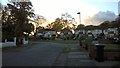
Junction of Vera Avenue and Uplands Way, Grange Park
Image: © Paul Bryan
Taken: 5 Nov 2017
0.08 miles
2

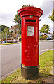
George V Pillar Box, Vera Avenue, London N21
Looking west down the north pavement of Vera Avenue, opposite the junction with Cadogan Gardens, we have this George V pillar box.
Image: © Christine Matthews
Taken: 1 Sep 2008
0.10 miles
3
George V Pillar Box, Vera Avenue, London N21
On the other side of the road to the left of the pillar box is a re-development site, where a derelict bungalow used to be.
Image: © Christine Matthews
Taken: 1 Sep 2008
0.10 miles
4

Redevelopment site on corner of Cadogan Gardens and Vera Avenue, London N21
For many years there was a derelict bungalow on this site, which was demolished some time ago. It looks as though work has started on the new construction.
Image: © Christine Matthews
Taken: 1 Sep 2008
0.12 miles
5
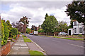
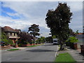
Vera Avenue, London N21
Looking down the north pavement of Vera Avenue in the direction of Grange Park Station.
Image: © Christine Matthews
Taken: 1 Sep 2008
0.13 miles
6
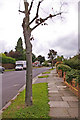
Vera Avenue, London N21
Looking east along the pavement on the north side of Vera Avenue, almost opposite the junction with Maxim Road.
Image: © Christine Matthews
Taken: 1 Sep 2008
0.13 miles
8

Cadogan Gardens, London N21
Cadogan Gardens as seen from the other side of Vera Avenue.
Image: © Christine Matthews
Taken: 1 Sep 2008
0.14 miles
9

Enfield Golf Course from Worlds End Lane, London N21
Part of the Enfield Golf Course extends as far as Worlds End Lane. This image was taken from Worlds End Lane.
Image: © Christine Matthews
Taken: 8 Feb 2008
0.15 miles
10
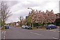
Vera Avenue, Grange Park, London N21
Looking west down Vera Avenue showing the wonderful display of Magnolia trees in this road.
Image: © Christine Matthews
Taken: 3 Apr 2008
0.15 miles