IMAGES TAKEN NEAR TO
Aylmer Road, LONDON, N2 0BT
Introduction
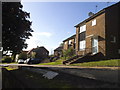
This page details the photographs taken nearby to Aylmer Road, N2 0BT by members of the Geograph project.
The Geograph project started in 2005 with the aim of publishing, organising and preserving representative images for every square kilometre of Great Britain, Ireland and the Isle of Man.

There are currently over 7.5m images from over14,400 individuals and you can help contribute to the project by visiting https://www.geograph.org.uk
Image Map
Images are licensed for reuse under creativecommons.org/licenses/by-sa/2.0
Notes
- Clicking on the map will re-center to the selected point.
- The higher the marker number, the further away the image location is from the centre of the postcode.
Image Listing (75 Images Found)
Images are licensed for reuse under creativecommons.org/licenses/by-sa/2.0
Image
Details
Distance
10
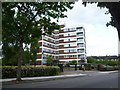
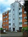
High Sheldon
The north end of Sheldon Avenue is now a cul-de-sac - see http://www.geograph.org.uk/photo/4529951 Near this northern end of Sheldon Avenue are two blocks of flats with a private entrance. They are known as High Sheldon and this is the northern block.
Image: © Marathon
Taken: 17 Jun 2015
0.08 miles