IMAGES TAKEN NEAR TO
Oakleigh Park North, LONDON, N20 9NH
Introduction
This page details the photographs taken nearby to Oakleigh Park North, N20 9NH by members of the Geograph project.
The Geograph project started in 2005 with the aim of publishing, organising and preserving representative images for every square kilometre of Great Britain, Ireland and the Isle of Man.

There are currently over 7.5m images from over14,400 individuals and you can help contribute to the project by visiting https://www.geograph.org.uk
Image Map
Images are licensed for reuse under creativecommons.org/licenses/by-sa/2.0
Notes
- Clicking on the map will re-center to the selected point.
- The higher the marker number, the further away the image location is from the centre of the postcode.
Image Listing (42 Images Found)
Images are licensed for reuse under creativecommons.org/licenses/by-sa/2.0
Image
Details
Distance
1
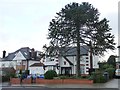
Large monkey puzzle tree, Chandos Avenue, Whetstone
As old as the houses, I suspect, and definitely taller. The house was built around 1920.
Image: © Christine Johnstone
Taken: 7 Jan 2016
0.08 miles
2
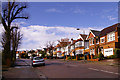
Chandos Avenue, London N20
Looking up Chandos Avenue towards Whetstone.
Image: © Christine Matthews
Taken: 13 Apr 2008
0.10 miles
3
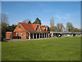
The Pavilion Study Centre
Located in Dame Alice Owens Open Ground, the centre is Barnet's secondary pupil referal unit handling children excluded from normal schools.
Image: © Martin Addison
Taken: 6 Apr 2007
0.10 miles
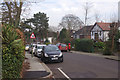
4

Chandos Avenue, N20
Viewed at the Oakleigh Park end. The buildings on the horizon are in Cockfosters.
Image: © Martin Addison
Taken: 6 Apr 2007
0.14 miles
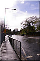
5
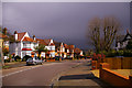
Oakleigh Park North
Oakleigh Park is a name invented by the Whetstone Freehold Estate Company who acquired land here in 1869. It intended to establish a 'superior suburb' and the name was firmly established when the nearby railway station was so named in 1873. Certainly the houses here on Oakleigh Park North are of the superior sort, although in practice much of the area was built up after the estate had been sold.
Image: © Stephen McKay
Taken: 6 Feb 2017
0.15 miles
6
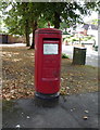
Elizabeth II postbox on Oakleigh Park South N20
Postbox No. N20 2.
Image: © JThomas
Taken: 3 Sep 2016
0.16 miles
7
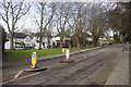
Oakleigh Park South
Oakleigh Park is a name invented by a Victorian development company for this area to the east of Whetstone. It has survived largely because the Great Northern Railway used the name for its local station (rather than plain 'Whetstone' as originally intended). The houses here where Oakleigh Avenue meets Oakleigh Park South by a small triangular green are large detached properties.
Image: © Stephen McKay
Taken: 6 Feb 2017
0.16 miles
8
Chandos Avenue, London N20
Chandos Avenue looking down the hill towards Netherlands Road.
Image: © Christine Matthews
Taken: 13 Apr 2008
0.16 miles
9
Bus stop, Netherlands Road outside Oakleigh Park Station, London N20
Image: © Christine Matthews
Taken: 13 Apr 2008
0.17 miles
10
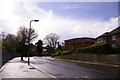
Netherlands Road, London N20
Looking up the hill. Oakleigh Park Station is on the left.
Image: © Christine Matthews
Taken: 13 Apr 2008
0.17 miles