IMAGES TAKEN NEAR TO
Totteridge Common, LONDON, N20 8LS
Introduction
This page details the photographs taken nearby to Totteridge Common, N20 8LS by members of the Geograph project.
The Geograph project started in 2005 with the aim of publishing, organising and preserving representative images for every square kilometre of Great Britain, Ireland and the Isle of Man.

There are currently over 7.5m images from over14,400 individuals and you can help contribute to the project by visiting https://www.geograph.org.uk
Image Map
Images are licensed for reuse under creativecommons.org/licenses/by-sa/2.0
Notes
- Clicking on the map will re-center to the selected point.
- The higher the marker number, the further away the image location is from the centre of the postcode.
Image Listing (27 Images Found)
Images are licensed for reuse under creativecommons.org/licenses/by-sa/2.0
Image
Details
Distance
1
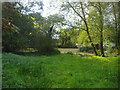
Small pond on Totteridge Lane
This is the other side of Ellern Mede farm from the long pond.
Image: © David Howard
Taken: 1 Oct 2008
0.03 miles
2
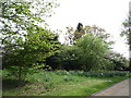
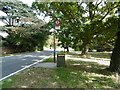
Trees, Totteridge Common
Just off the A5109.
Image: © JThomas
Taken: 15 Apr 2017
0.07 miles
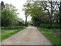
4
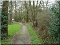
Path, Totteridge Common
Along the broad verge of the A5109.
Image: © Robin Webster
Taken: 21 Mar 2013
0.10 miles
5
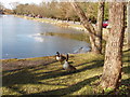
Geese by frozen Long Pond, Totteridge Common
View west along the A5109 to Edgware. The same pond in summer is shown in Image
Image: © David Hawgood
Taken: 5 Mar 2006
0.10 miles
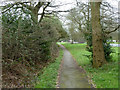
6
Path, Totteridge Common
Along the broad verge of the A5109.
Image: © Robin Webster
Taken: 21 Mar 2013
0.12 miles
7
Totteridge Common
In Nairn's London (1966) Ian Nairn says of Totteridge: "More of a phenomenon than a village. It is a ridge-back, south-west of Barnet, and the views are green in both directions. North Finchley should show up on the southern skyline but doesn't, and the miracle of the green Belt has worked again. The country here is far better than the bedraggled fields further out, sprinkled with pylons and motorways. A strip of green winds along the ridge: wavy sides, big trees, sometimes five yards wide and sometimes fifty. There is a long pond. Behind are the houses of a hundred drawing-room comedies: 1910-ish, big, comfortable and in fact very nice indeed. And this dream goes on for a whole mile. The curtain is always rising on the maid setting the table for tea. Here there is a contract with the landscape and it becomes a marvellous place, unlike anywhere else near London. Signposts for crows would read Barnet 1, Edgware 2."
Public footpaths link the Common to the Folly Brook valley to the south and to the Dollis Brook valley to the north.
Image: © Marathon
Taken: 5 Oct 2016
0.16 miles
8
Fishing on the common
The lake beside Totteridge Common (A5109) is popular with anglers throughout the year despite the, sometimes heavy, traffic passing close behind them.
Image: © Martin Addison
Taken: Unknown
0.16 miles
9
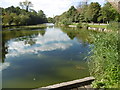
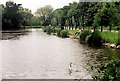
Long Pond on Totteridge Common
In Nairn's London (1966) Ian Nairn says of Totteridge: "More of a phenomenon than a village. It is a ridge-back, south-west of Barnet, and the views are green in both directions. North Finchley should show up on the southern skyline but doesn't, and the miracle of the green Belt has worked again. The country here is far better than the bedraggled fields further out, sprinkled with pylons and motorways. A strip of green winds along the ridge: wavy sides, big trees, sometimes five yards wide and sometimes fifty. There is a long pond. Behind are the houses of a hundred drawing-room comedies: 1910-ish, big, comfortable and in fact very nice indeed. And this dream goes on for a whole mile. The curtain is always rising on the maid setting the table for tea. Here there is a contract with the landscape and it becomes a marvellous place, unlike anywhere else near London. Signposts for crows would read Barnet 1, Edgware 2."
The ponds on Totteridge Common were probably originally dug for gravel extraction. Public footpaths link the Common to the Folly Brook valley to the south and to the Dollis Brook valley to the north. Long Pond is now managed chiefly for angling.
Image: © Marathon
Taken: 5 Oct 2016
0.17 miles
10
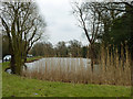
The Long Pond, Totteridge Common
Viewed from a bench on the common, rather oddly placed so that a view of the pond is obscured by reeds, which only grow at this end.
Image: © Robin Webster
Taken: 21 Mar 2013
0.19 miles