IMAGES TAKEN NEAR TO
Elder Close, LONDON, N20 8DN
Introduction
This page details the photographs taken nearby to Elder Close, N20 8DN by members of the Geograph project.
The Geograph project started in 2005 with the aim of publishing, organising and preserving representative images for every square kilometre of Great Britain, Ireland and the Isle of Man.

There are currently over 7.5m images from over14,400 individuals and you can help contribute to the project by visiting https://www.geograph.org.uk
Image Map (Loading...)


Getting Data...Please wait
Leaflet Map data © OpenStreetMap
Images are licensed for reuse under creativecommons.org/licenses/by-sa/2.0
Notes
- Clicking on the map will re-center to the selected point.
- The higher the marker number, the further away the image location is from the centre of the postcode.
Image Listing (69 Images Found)
Images are licensed for reuse under creativecommons.org/licenses/by-sa/2.0
Image
Details
Distance
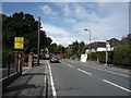
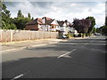
3

Longland Drive, Totteridge
Longland Drive, first turning left from Totteridge Lane after you pass the Dollis Valley Green Space.
Image: © Christine Matthews
Taken: 20 Oct 2005
0.05 miles
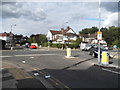
4
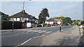
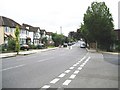
Zebra crossing, Totteridge
A pedestrian crossing in Totteridge.
Image: © Peter Mackenzie
Taken: 10 Sep 2019
0.06 miles
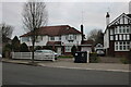
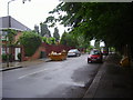
7
Longland Drive at the junction of Totteridge Lane
Image: © David Howard
Taken: 29 Jul 2015
0.06 miles
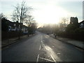
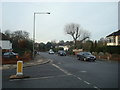
10
Totteridge: Longland Drive
The 1920 Edition of the Ordnance Survey's 6" to the mile map shows only open fields running down from Totteridge Green across this area to Dollis Brook. However by the time that the 1938 Edition was published the whole area had been developed for residential housing, almost certainly due to the proximity of Totteridge and Whetstone Underground railway station.
Image: © Nigel Cox
Taken: 8 Sep 2008
0.08 miles