IMAGES TAKEN NEAR TO
Lynton Mead, LONDON, N20 8DH
Introduction
This page details the photographs taken nearby to Lynton Mead, N20 8DH by members of the Geograph project.
The Geograph project started in 2005 with the aim of publishing, organising and preserving representative images for every square kilometre of Great Britain, Ireland and the Isle of Man.

There are currently over 7.5m images from over14,400 individuals and you can help contribute to the project by visiting https://www.geograph.org.uk
Image Map
Images are licensed for reuse under creativecommons.org/licenses/by-sa/2.0
Notes
- Clicking on the map will re-center to the selected point.
- The higher the marker number, the further away the image location is from the centre of the postcode.
Image Listing (19 Images Found)
Images are licensed for reuse under creativecommons.org/licenses/by-sa/2.0
Image
Details
Distance
2

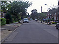
Longland Drive, Totteridge
Looking north east.
Image: © JThomas
Taken: 3 Sep 2016
0.13 miles
3

Ventnor Drive, Totteridge
Very similar to Lynton Mead, the next street along. I often wonder if streets were named after where the builders had gone on holiday.
Image: © Des Blenkinsopp
Taken: 26 Feb 2019
0.16 miles

5
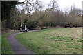
Whetstone Stray
Young ladies walking the dog beside Dollis Brook. The footpath forms part of the Dollis Valley Green Walk.
Image: © Martin Addison
Taken: 20 Feb 2009
0.19 miles
6
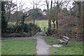
Bridge Over Dollis Brook
The footbridge connects both sides of Whetstone Stray. The houses beyond are on Longland Drive.
Image: © Martin Addison
Taken: 20 Feb 2009
0.21 miles

8
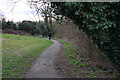
Whetstone Stray
The footpath forms part of the Dollis Valley Green Walk - the brook is out of shot on the right.
Image: © Martin Addison
Taken: 20 Feb 2009
0.21 miles

10
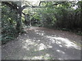
The Dollis Valley Greenwalk at Whetstone Stray Open Space
The Dollis Valley Greenwalk is about ten miles long and runs from Hampstead Heath to join the Dollis Brook near the North Circular Road and then follows the brook to beyond its source at Moat Mount.
The Dollis Brook rises at Moat Mount near Arkley, firstly flowing eastwards through the open countryside of Totteridge Fields to Chipping Barnet and then through the suburbs of Barnet to Hendon. Its route can be traced by the thin strip of woodland along the riverbank and ribbon of open land on either side which provides a valuable green corridor. At Hendon the Dollis Brook meets the Mutton Brook and becomes the River Brent which then flows into the Welsh Harp Reservoir and subsequently the River Thames at Brentford.
Whetstone Stray Open Space is between Totteridge Lane and Laurel View. Here the Dollis Brook is to the right.
Image: © Marathon
Taken: 28 Sep 2016
0.22 miles