IMAGES TAKEN NEAR TO
Friern Barnet Lane, LONDON, N20 0XZ
Introduction
This page details the photographs taken nearby to Friern Barnet Lane, N20 0XZ by members of the Geograph project.
The Geograph project started in 2005 with the aim of publishing, organising and preserving representative images for every square kilometre of Great Britain, Ireland and the Isle of Man.

There are currently over 7.5m images from over14,400 individuals and you can help contribute to the project by visiting https://www.geograph.org.uk
Image Map
Images are licensed for reuse under creativecommons.org/licenses/by-sa/2.0
Notes
- Clicking on the map will re-center to the selected point.
- The higher the marker number, the further away the image location is from the centre of the postcode.
Image Listing (61 Images Found)
Images are licensed for reuse under creativecommons.org/licenses/by-sa/2.0
Image
Details
Distance
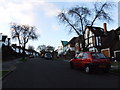
1
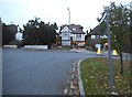
Friern Barnet Lane at the junction of Friary Road
Image: © David Howard
Taken: 6 Nov 2014
0.05 miles
2
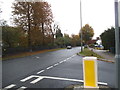
Friern Barnet Lane at the junction of Manor Drive
Looking towards Friary Park on the left
Image: © David Howard
Taken: 16 Oct 2014
0.05 miles
3
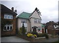
House on Friars Avenue, Friern Barnet
These are not the original metal windows but have used the correct design.
Image: © David Howard
Taken: 18 Nov 2015
0.07 miles
4
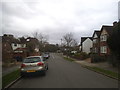
Friars Avenue, Friern Barnet
Looking towards Manor Road
Image: © David Howard
Taken: 18 Nov 2015
0.07 miles
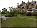
6
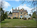
Friary House in Friary Park
Friary Park was home to the Knights Hospitallers in the Middle Ages, and of Friern Barnet Manor House from the sixteenth century. The name Friary Park was adopted in the 1870s and it was opened to the public in 1910. Friary Park was to have been officially opened by the Lord Mayor of London on Saturday 7th May 1910. However, the death of King Edward VIIth the day before meant that the ceremony had to be postponed although the park was thrown open to those who wished to see it. The opening ceremony eventually took place on 21st July 1910.
A cafe is housed in the 19th century Gothic Revival Friary House, seen here.
Image: © Marathon
Taken: 21 Sep 2016
0.08 miles
7
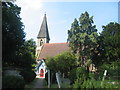
St James Church, Friern Barnet
The church of St James The Great, Friern Barnet, is located on the corner of Friern Barnet Lane and Friary Road. The originally Norman church was extensively rebuilt in its present form in 1853.
Image: © John Attfield
Taken: 4 Sep 2005
0.08 miles
8
Friary House in Friary Park
Friary Park was home to the Knights Hospitallers in the Middle Ages, and of Friern Barnet Manor House from the sixteenth century. The name Friary Park was adopted in the 1870s and it was opened to the public in 1910. Friary Park was to have been officially opened by the Lord Mayor of London on Saturday 7th May 1910. However, the death of King Edward VIIth the day before meant that the ceremony had to be postponed although the park was thrown open to those who wished to see it. The opening ceremony eventually took place on 21st July 1910.
A cafe is housed in the 19th century Gothic Revival Friary House, seen here.
Image: © Marathon
Taken: 21 Sep 2016
0.08 miles
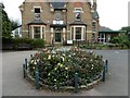
9
Friary House, Friary Park, Friern Barnet
A cafe is in the conservatory end.
Image: © Robin Webster
Taken: 6 Apr 2013
0.08 miles
10
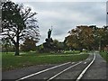
Cycle Track in Friary Park
Cycle Track in Friary Park, Friern Barnet Lane, Friern Barnet
Image: © Christine Matthews
Taken: 29 Oct 2005
0.09 miles