IMAGES TAKEN NEAR TO
York Way, LONDON, N1C 4AT
Introduction
This page details the photographs taken nearby to York Way, N1C 4AT by members of the Geograph project.
The Geograph project started in 2005 with the aim of publishing, organising and preserving representative images for every square kilometre of Great Britain, Ireland and the Isle of Man.

There are currently over 7.5m images from over14,400 individuals and you can help contribute to the project by visiting https://www.geograph.org.uk
Image Map
Images are licensed for reuse under creativecommons.org/licenses/by-sa/2.0
Notes
- Clicking on the map will re-center to the selected point.
- The higher the marker number, the further away the image location is from the centre of the postcode.
Image Listing (1195 Images Found)
Images are licensed for reuse under creativecommons.org/licenses/by-sa/2.0
Image
Details
Distance
3
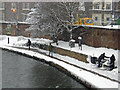
Regent's Canal, King's Cross
A few people brave the canal towpath west of York Way on a bitterly cold day with snow falling.
Image: © Stephen McKay
Taken: 2 Feb 2009
0.02 miles
5
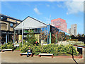
Waitrose Store on a Tunnel
Trains in and out of Kings Cross Station go under here.
Image: © Des Blenkinsopp
Taken: 18 Oct 2018
0.03 miles
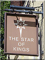
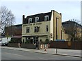
6
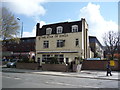
The Star of Kings
Public house on York Way.
Image: © JThomas
Taken: 23 Apr 2016
0.03 miles
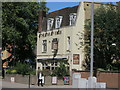
10
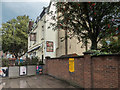
The Star of Kings Public House, York Way, King's Cross, London
Image: © Christine Matthews
Taken: 13 Oct 2016
0.03 miles