IMAGES TAKEN NEAR TO
Killick Street, LONDON, N1 9BD
Introduction
This page details the photographs taken nearby to Killick Street, N1 9BD by members of the Geograph project.
The Geograph project started in 2005 with the aim of publishing, organising and preserving representative images for every square kilometre of Great Britain, Ireland and the Isle of Man.

There are currently over 7.5m images from over14,400 individuals and you can help contribute to the project by visiting https://www.geograph.org.uk
Image Map
Images are licensed for reuse under creativecommons.org/licenses/by-sa/2.0
Notes
- Clicking on the map will re-center to the selected point.
- The higher the marker number, the further away the image location is from the centre of the postcode.
Image Listing (1360 Images Found)
Images are licensed for reuse under creativecommons.org/licenses/by-sa/2.0
Image
Details
Distance
1
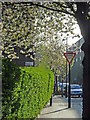
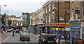
Collier Street, Pentonville
Pentonville, the area to the east of King's Cross station, is usually regarded as an unlovely corner of London, but it can be leafy and pleasant - especially on a glorious spring morning.
Image: © Stephen McKay
Taken: 16 Apr 2010
0.01 miles
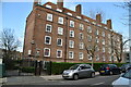
2

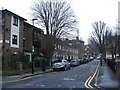
Collier Street, Pentonville
Elegant buildings at the junction between Collier Street and Northdown Street.
Image: © Stephen McKay
Taken: 3 Aug 2010
0.02 miles
4

38 Keystone Crescent N1
At the junction with Caledonian Road
Image: © Robin Sones
Taken: 30 Sep 2009
0.03 miles
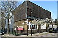
6
Al-Nehar Mosque & Education Centre, Caledonian Road
The mosque occupies the premises of the former Star & Garter public house, 70 Caledonian Road
Image: © Jim Osley
Taken: 21 Nov 2018
0.03 miles
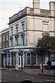
9
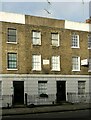
77 Caledonian Road, Islington
Part of the Listed Grade II terrace seen here https://www.geograph.org.uk/photo/7373098.
The plaques at first floor level are parish boundary markers. This part of Caledonian Road was developed without reference to the pre-existing parish boundary which consequently cuts switches back and forth across the road. There are several such markers in the immediate vicinity, including in Keystone Crescent https://www.geograph.org.uk/photo/1724191
Image: © Alan Murray-Rust
Taken: 27 Dec 2022
0.04 miles
10
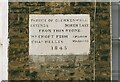
Boundary stone, 77 Caledonian Road, Islington
See https://www.geograph.org.uk/photo/7373103 for location and more information.
Image: © Alan Murray-Rust
Taken: 27 Dec 2022
0.04 miles