IMAGES TAKEN NEAR TO
Colva Walk, LONDON, N19 5DB
Introduction
This page details the photographs taken nearby to Colva Walk, N19 5DB by members of the Geograph project.
The Geograph project started in 2005 with the aim of publishing, organising and preserving representative images for every square kilometre of Great Britain, Ireland and the Isle of Man.

There are currently over 7.5m images from over14,400 individuals and you can help contribute to the project by visiting https://www.geograph.org.uk
Image Map (Loading...)


Getting Data...Please wait
Leaflet Map data © OpenStreetMap
Images are licensed for reuse under creativecommons.org/licenses/by-sa/2.0
Notes
- Clicking on the map will re-center to the selected point.
- The higher the marker number, the further away the image location is from the centre of the postcode.
Image Listing (218 Images Found)
Images are licensed for reuse under creativecommons.org/licenses/by-sa/2.0
Image
Details
Distance
1
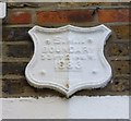
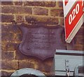
Old Boundary Marker by Dartmouth Park Hill
Parish Boundary Marker by the UC road, in parish of Highgate And Muswell Hill (Islington District), Dartmouth Park Hill N19, attached to wall above porches of Nos. 90 & 92.
Surveyed
Milestone Society National ID: MX_SMI03pb.
Image: © Milestone Society
Taken: Unknown
0.03 miles
2
Hargrave Place N19 Fading Anti-Nuclear Wall Art
This smiley face anti-nuclear power wall painting is now quite faded but reads 'nuclear power no thank you'. I first saw it in the 1980's when it was quite readable and I suspect it dates from the mid to late 1970's. At that time Islington Council were demolishing much of the old housing stock in the area and some properties were squatted before they came down. In 1979 this anti-nuclear symbol was quite ubiquitous in western Europe and I had a German badge that read 'atomkraft nein danke' and I guess I thought I was cool.
Image: © John Kingdon
Taken: 31 Aug 2024
0.04 miles
5
Old Boundary Marker by Dartmouth Park Hill, Highgate and Muswell Hill Parish
Parish Boundary Marker by the UC road, in parish of Highgate and Muswell Hill (Islington District), Dartmouth Park Hill N19, corner with Bredgar Road, attached to first floor wall of No 122 Dartmouth Park Hill.
Surveyed
Milestone Society National ID: MX_SMI04pb.
Image: © Milestone Society
Taken: Unknown
0.07 miles
8
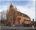
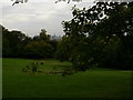
St Peter, Bredgar Road, Upper Holloway, London N19
This church has been converted into flats.
Image: © John Salmon
Taken: 3 Feb 2008
0.08 miles
10
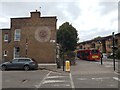
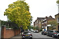
Cat in Raydon Street
This cat was walking along the pavement in Raydon Street near Whittington Hospital. It then jumped through a tiny gap which looked about half its size and was then staring back out at me.
Image: © Marathon
Taken: 10 Aug 2018
0.09 miles