IMAGES TAKEN NEAR TO
Wedmore Street, LONDON, N19 4RT
Introduction
This page details the photographs taken nearby to Wedmore Street, N19 4RT by members of the Geograph project.
The Geograph project started in 2005 with the aim of publishing, organising and preserving representative images for every square kilometre of Great Britain, Ireland and the Isle of Man.

There are currently over 7.5m images from over14,400 individuals and you can help contribute to the project by visiting https://www.geograph.org.uk
Image Map
Images are licensed for reuse under creativecommons.org/licenses/by-sa/2.0
Notes
- Clicking on the map will re-center to the selected point.
- The higher the marker number, the further away the image location is from the centre of the postcode.
Image Listing (121 Images Found)
Images are licensed for reuse under creativecommons.org/licenses/by-sa/2.0
Image
Details
Distance
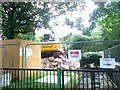
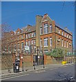
1
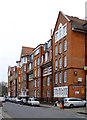
Weatherbury House, Upper Holloway
London County Council (LCC) mansion block built in 1904 to the designs of architect W.E. Riley. For a comprehensive history of the site visit this http://www.locallocalhistory.co.uk/municipal-housing/wedmore/final/index.htm.
Image: © Jim Osley
Taken: 17 Feb 2016
0.00 miles
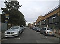
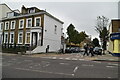
3
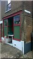
Ivo Place Holloway London
The old shopfront now displays an "Age of Stupid" sign. A sign of the times?
Image: © John Kingdon
Taken: 28 Sep 2021
0.02 miles
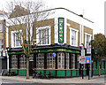
7
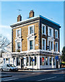
Holloway : "The Floirin" public house
Formerly known as "The Mulberry Tree".
Image: © Jim Osley
Taken: 24 Dec 2018
0.12 miles
9
Yerbury Primary School, Upper Holloway
Opened in 1884.
Image: © Jim Osley
Taken: 9 Apr 2015
0.13 miles
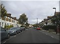
10
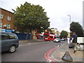
Holloway Road
This is the narrow part towards the north end, the wide part was because they once had a tramline down the middle, now the actual road there is mainly back to two lanes with the rest only for buses.
Image: © David Howard
Taken: 28 Aug 2014
0.13 miles