IMAGES TAKEN NEAR TO
Cornwallis Road, LONDON, N19 4LU
Introduction
This page details the photographs taken nearby to Cornwallis Road, N19 4LU by members of the Geograph project.
The Geograph project started in 2005 with the aim of publishing, organising and preserving representative images for every square kilometre of Great Britain, Ireland and the Isle of Man.

There are currently over 7.5m images from over14,400 individuals and you can help contribute to the project by visiting https://www.geograph.org.uk
Image Map
Images are licensed for reuse under creativecommons.org/licenses/by-sa/2.0
Notes
- Clicking on the map will re-center to the selected point.
- The higher the marker number, the further away the image location is from the centre of the postcode.
Image Listing (104 Images Found)
Images are licensed for reuse under creativecommons.org/licenses/by-sa/2.0
Image
Details
Distance

9
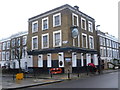
The disused Devonshire Castle
On the corner of Axminster Road and Tollington Way in Upper Holloway, the Devonshire Castle was an attractive looking pub. It also has an attractive sign which actually resembles Bodiam Castle in East Sussex!
Image: © Marathon
Taken: 28 Jan 2015
0.07 miles