IMAGES TAKEN NEAR TO
Grenville Road, LONDON, N19 4EH
Introduction
This page details the photographs taken nearby to Grenville Road, N19 4EH by members of the Geograph project.
The Geograph project started in 2005 with the aim of publishing, organising and preserving representative images for every square kilometre of Great Britain, Ireland and the Isle of Man.

There are currently over 7.5m images from over14,400 individuals and you can help contribute to the project by visiting https://www.geograph.org.uk
Image Map (Loading...)


Getting Data...Please wait
Leaflet Map data © OpenStreetMap
Images are licensed for reuse under creativecommons.org/licenses/by-sa/2.0
Notes
- Clicking on the map will re-center to the selected point.
- The higher the marker number, the further away the image location is from the centre of the postcode.
Image Listing (176 Images Found)
Images are licensed for reuse under creativecommons.org/licenses/by-sa/2.0
Image
Details
Distance
3
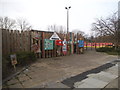
Adventure playground entrance on Grenville Road
Image: © David Howard
Taken: 13 Mar 2015
0.03 miles
5
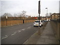
Nugent Road, Upper Holloway
Crossing the railway line
Image: © David Howard
Taken: 13 Mar 2015
0.05 miles
6
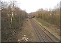
Railway line from Nugent Road, Upper Holloway
Heading towards Crouch Hill station
Image: © David Howard
Taken: 13 Mar 2015
0.05 miles
8
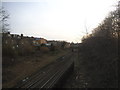
Railway line from Nugent Road, Upper Holloway
Heading to Upper Holloway station
Image: © David Howard
Taken: 13 Mar 2015
0.06 miles
9
Spears Road at the junction of Nugent Road
Image: © David Howard
Taken: 13 Mar 2015
0.07 miles
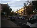
10
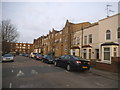
Housing, Hanley Road, Crouch Hill
Various types of residential houses along this street.
Image: © David Anstiss
Taken: 27 Jan 2013
0.08 miles