IMAGES TAKEN NEAR TO
Marie Lloyd Gardens, LONDON, N19 3YN
Introduction
This page details the photographs taken nearby to Marie Lloyd Gardens, N19 3YN by members of the Geograph project.
The Geograph project started in 2005 with the aim of publishing, organising and preserving representative images for every square kilometre of Great Britain, Ireland and the Isle of Man.

There are currently over 7.5m images from over14,400 individuals and you can help contribute to the project by visiting https://www.geograph.org.uk
Image Map
Images are licensed for reuse under creativecommons.org/licenses/by-sa/2.0
Notes
- Clicking on the map will re-center to the selected point.
- The higher the marker number, the further away the image location is from the centre of the postcode.
Image Listing (272 Images Found)
Images are licensed for reuse under creativecommons.org/licenses/by-sa/2.0
Image
Details
Distance
2
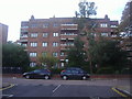
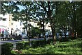
Flats on Warltersville Road, Upper Holloway
Image: © David Howard
Taken: 17 Oct 2013
0.06 miles
5
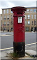
Victorian postbox on Beaumont Rise
Image: © JThomas
Taken: 23 Apr 2016
0.10 miles
6

Cypher, Victorian postbox on Beaumont Rise
Postbox No. N19 18.
See Image] for postbox.
Image: © JThomas
Taken: 23 Apr 2016
0.10 miles
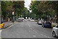
7
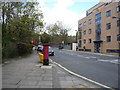
Beaumont Rise
Looking west showing position of Victorian Postbox No. N19 18.
See Image] for postbox.
Image: © JThomas
Taken: 23 Apr 2016
0.10 miles
8
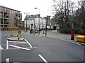
Beaumont Rise
Showing position of Victorian Postbox No. N19 18.
See Image] for postbox.
Image: © JThomas
Taken: 23 Apr 2016
0.10 miles
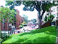
9
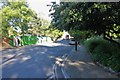
Beaumont Rise, Upper Holloway
By Elthorne Park on the right
Image: © David Howard
Taken: 5 May 2020
0.10 miles