IMAGES TAKEN NEAR TO
Holloway Road, LONDON, N19 3JF
Introduction
This page details the photographs taken nearby to Holloway Road, N19 3JF by members of the Geograph project.
The Geograph project started in 2005 with the aim of publishing, organising and preserving representative images for every square kilometre of Great Britain, Ireland and the Isle of Man.

There are currently over 7.5m images from over14,400 individuals and you can help contribute to the project by visiting https://www.geograph.org.uk
Image Map
Images are licensed for reuse under creativecommons.org/licenses/by-sa/2.0
Notes
- Clicking on the map will re-center to the selected point.
- The higher the marker number, the further away the image location is from the centre of the postcode.
Image Listing (291 Images Found)
Images are licensed for reuse under creativecommons.org/licenses/by-sa/2.0
Image
Details
Distance
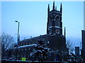
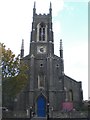
1
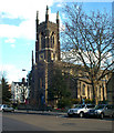
St John's Church, Holloway Road, Upper Holloway
A Commissioners' church, built 1826-1828 to the designs of architect Charles Barry as Upper Holloway Parish Church
Image: © Jim Osley
Taken: 8 Mar 2007
0.01 miles
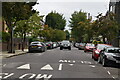
5
St John the Evangelist, Holloway Road N19
Looking up St John's Grove
Image: © Robin Sones
Taken: 18 Dec 2010
0.02 miles

8
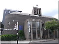
St Gabriel of our Lady of Sorrows Church, St John's Villas
At the junction with Holloway Road
Image: © Robin Sones
Taken: 13 Jun 2018
0.03 miles
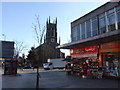
10
St John the Evangelist Church, St John's Grove N19
Image: © Robin Sones
Taken: 12 Oct 2009
0.03 miles