IMAGES TAKEN NEAR TO
Nicholay Road, LONDON, N19 3EZ
Introduction
This page details the photographs taken nearby to Nicholay Road, N19 3EZ by members of the Geograph project.
The Geograph project started in 2005 with the aim of publishing, organising and preserving representative images for every square kilometre of Great Britain, Ireland and the Isle of Man.

There are currently over 7.5m images from over14,400 individuals and you can help contribute to the project by visiting https://www.geograph.org.uk
Image Map
Images are licensed for reuse under creativecommons.org/licenses/by-sa/2.0
Notes
- Clicking on the map will re-center to the selected point.
- The higher the marker number, the further away the image location is from the centre of the postcode.
Image Listing (105 Images Found)
Images are licensed for reuse under creativecommons.org/licenses/by-sa/2.0
Image
Details
Distance
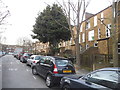
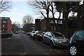
2
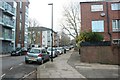
Housing estate on Ashbrook Road, Archway
Image: © David Howard
Taken: 2 Jan 2021
0.09 miles
3
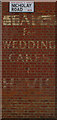
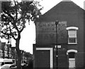
Baker's shop advertisement
Old painted shop advertisement, Nicholay Road, Upper Holloway
Image: © Jim Osley
Taken: 8 Mar 2007
0.10 miles
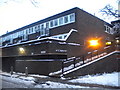
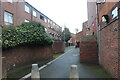
10
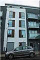
Kinver House on Ashbrook Road, Archway
A fairly new block of flats
Image: © David Howard
Taken: 2 Jan 2021
0.11 miles