IMAGES TAKEN NEAR TO
Ashley Road, LONDON, N19 3AG
Introduction
This page details the photographs taken nearby to Ashley Road, N19 3AG by members of the Geograph project.
The Geograph project started in 2005 with the aim of publishing, organising and preserving representative images for every square kilometre of Great Britain, Ireland and the Isle of Man.

There are currently over 7.5m images from over14,400 individuals and you can help contribute to the project by visiting https://www.geograph.org.uk
Image Map (Loading...)


Getting Data...Please wait
Leaflet Map data © OpenStreetMap
Images are licensed for reuse under creativecommons.org/licenses/by-sa/2.0
Notes
- Clicking on the map will re-center to the selected point.
- The higher the marker number, the further away the image location is from the centre of the postcode.
Image Listing (226 Images Found)
Images are licensed for reuse under creativecommons.org/licenses/by-sa/2.0
Image
Details
Distance
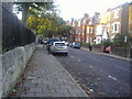
4
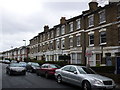
Victorian Terraced Houses North London
Both the two story and three storey houses shown here have almost all been converted to flats and apartments. They are in Shaftesbury Rd that runs between Crouch Hill and Hornsey Rd not far from Finsbury park
Image: © Nigel Mykura
Taken: 13 Jan 2008
0.07 miles
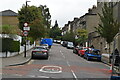
6

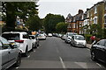
Ashley Road at the corner of Crouch Hill
Image: © David Howard
Taken: 5 May 2020
0.07 miles
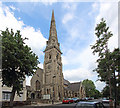
8
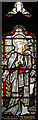
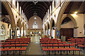
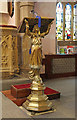
St Mary, Hornsey Rise - Stained glass window
Image: © John Salmon
Taken: 24 Jun 2015
0.07 miles