IMAGES TAKEN NEAR TO
Duncan Street, LONDON, N1 8FR
Introduction
This page details the photographs taken nearby to Duncan Street, N1 8FR by members of the Geograph project.
The Geograph project started in 2005 with the aim of publishing, organising and preserving representative images for every square kilometre of Great Britain, Ireland and the Isle of Man.

There are currently over 7.5m images from over14,400 individuals and you can help contribute to the project by visiting https://www.geograph.org.uk
Image Map
Images are licensed for reuse under creativecommons.org/licenses/by-sa/2.0
Notes
- Clicking on the map will re-center to the selected point.
- The higher the marker number, the further away the image location is from the centre of the postcode.
Image Listing (918 Images Found)
Images are licensed for reuse under creativecommons.org/licenses/by-sa/2.0
Image
Details
Distance
2
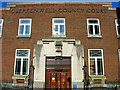
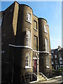
Former Clerkenwell County Court Building
This building dating from 1931, and actually located on Duncan Street in the heart of Islington rather than Clerkenwell, closed as a court in 2006 when the new Clerkenwell and Shoreditch County Court opened on Gee Street. Proposals exist to convert it into housing.
Image: © Stephen McKay
Taken: 19 Feb 2010
0.01 miles
3
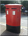
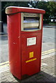
Double aperture Elizabeth II postbox on Duncan Terrace, London N1
Image: © JThomas
Taken: 5 Aug 2017
0.02 miles
4
Royal Mail business box on Duncan Terrace, London N1
Image: © JThomas
Taken: 5 Aug 2017
0.02 miles
5
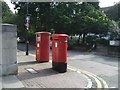
Duncan Terrace, London N1
Showing position of Postboxes Nos. N1 37 and N1 137 and business postbox No. N1 40.
See Image] for postbox.
See Image] for business box.
Image: © JThomas
Taken: 5 Aug 2017
0.02 miles
6
Duncan Terrace, London N1
Showing position of Postboxes Nos. N1 37 and N1 137 and business postbox No. N1 40.
See Image] for postbox.
See Image] for business box.
Image: © JThomas
Taken: 5 Aug 2017
0.02 miles
7
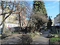
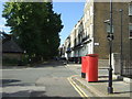
View south along Duncan Terrace, Islington
The gardens on the left mark the line of the New River.
Image: © Christopher Hilton
Taken: 14 Sep 2016
0.02 miles
8
Duncan Terrace, Islington, London N1
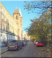
The imposing Roman Catholic Church of St John the Evangelist on Duncan Terrace. On the right are Colebrooke Gardens, an elongated public park. The present church was consecrated in 1843 having been financed by a small group of local believers and built by local Irish labourers. At the time of opening, the two towers that were planned were not built. The church was original set in a very rural setting, surrounded by hayfields. A brick kiln on Colebrooke Row provided building materials for many of the local buildings that were constructed in the early 1800s. For some reason, when the church towers were built during Father Oakeley’s tenure, they were made smaller and non-identical than those envisaged in the original plans. An access point onto the Regent's Canal towpath, near to the Islington canal tunnel is situated 2-3 minutes walk away, behind the photographer.
Image: © David Hallam-Jones
Taken: 23 Nov 2013
0.02 miles
9
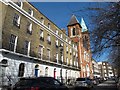
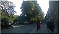
Duncan Terrace, N1 (4)
Looking north towards the (RC) Church of St. John the Evangelist.
Image: © Mike Quinn
Taken: 5 Mar 2014
0.02 miles