IMAGES TAKEN NEAR TO
Angel Road Works, Advent Way, LONDON, N18 3AH
Introduction
This page details the photographs taken nearby to Angel Road Works, Advent Way, N18 3AH by members of the Geograph project.
The Geograph project started in 2005 with the aim of publishing, organising and preserving representative images for every square kilometre of Great Britain, Ireland and the Isle of Man.

There are currently over 7.5m images from over14,400 individuals and you can help contribute to the project by visiting https://www.geograph.org.uk
Image Map
Images are licensed for reuse under creativecommons.org/licenses/by-sa/2.0
Notes
- Clicking on the map will re-center to the selected point.
- The higher the marker number, the further away the image location is from the centre of the postcode.
Image Listing (23 Images Found)
Images are licensed for reuse under creativecommons.org/licenses/by-sa/2.0
Image
Details
Distance
1
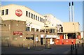
Edmonton: Coca-Cola plant, Eley's Industrial Estate, N18
This plant, on Nobel Road, is run by Coca-Cola Enterprises and has manufacture, bottling and product distribution facilities. The twin chimneys are, I think, evaporative condensers. Incidentally the maroon sign reads:
'This site has achieved 577 days since last LTA'
The acronym LTA may be in common usage in the world of factory health and safety, but its meaning is almost certainly unknown to the general public walking by. After a little research I am guessing that in this context LTA stands for Lost Time Accident.
Image: © Nigel Cox
Taken: 5 Mar 2008
0.04 miles
2
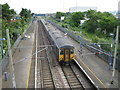
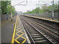
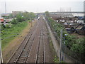
Edmonton: Angel Road railway station
Angel Road has to be one of the least used railway stations in London. It is nowhere near any houses, near only a few industrial premises and demands a walk along busy main roads to its only point of access. This is reflected in the number of trains that stop here during the day, about 10 during the morning rush-hour and then about 10 again during the evening rush-hour with a six hour gap in between. Yet oddly the station pre-dated all the general growth of Edmonton and was built as a country station where Angel Road, now the North Circular, crossed the line.
Here a southbound National Express train, not stopping of course, runs through the deserted station. For the train-spotters the leading unit was 317 732.
Image: © Nigel Cox
Taken: 10 Jun 2008
0.09 miles
3
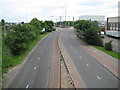
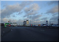
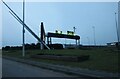
Edmonton: A1055 Meridian Way
I really cannot believe this photograph. 0919 on a weekday morning and barely a vehicle in sight. The A1055 was built as a north-south route between Tottenham Hale and Freezy Water north of Enfield to provide a bypass around Enfield and to provide HGV access to the numerous industrial estates in the area.
Image: © Nigel Cox
Taken: 10 Jun 2008
0.10 miles
4
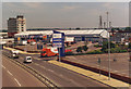
Ravenside Retail Park, The Angel Edmonton 1998
Taken from the footbridge returning from Burger King. Here is the more recent version http://www.geograph.org.uk/photo/2752212
Image: © David Howard
Taken: Unknown
0.10 miles
5
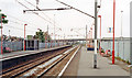
Angel Road railway station, Greater London, 2014
Opened in 1840 as "Edmonton" by the Northern & Eastern Railway on what is now the line from Liverpool Street to Broxbourne, this station was renamed "Water Lane" in 1849 and then Angel Road in 1864. It was the junction for Lower Edmonton from 1849 to 1964. In 2019 it was closed, being replaced by a new station called Meridian Water, some 400m to the south - see Image
View north towards Ponders End and Broxbourne. For more details, see http://www.disused-stations.org.uk/a/angel_road/index.shtml
Image: © Nigel Thompson
Taken: 25 Apr 2014
0.11 miles
7
Angel Road station, 1991
View northward, towards Broxbourne, Bishop's Stortford and Cambridge: ex-GER Liverpool Street - Cambridge via Lea Valley main line, electrified 1960 at London end.
Image: © Ben Brooksbank
Taken: 25 May 1991
0.12 miles
8
Angel Road railway station, London
Opened in 1840 by the Northern & Eastern Railway on what is now the line from Liverpool Street to Broxbourne, this station was the junction for Lower Edmonton from 1849 to 1964.
View south towards Northumberland Park and London. The branch line curved off to the right.
Image: © Nigel Thompson
Taken: 25 Apr 2014
0.12 miles
9
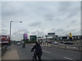
The North Circular from Argon Road, Edmonton
Argon Road gives access to all the retail and industrial parks along the A406.
Image: © David Howard
Taken: 13 Feb 2021
0.13 miles