IMAGES TAKEN NEAR TO
Park Avenue, LONDON, N18 2UP
Introduction
This page details the photographs taken nearby to Park Avenue, N18 2UP by members of the Geograph project.
The Geograph project started in 2005 with the aim of publishing, organising and preserving representative images for every square kilometre of Great Britain, Ireland and the Isle of Man.

There are currently over 7.5m images from over14,400 individuals and you can help contribute to the project by visiting https://www.geograph.org.uk
Image Map
Images are licensed for reuse under creativecommons.org/licenses/by-sa/2.0
Notes
- Clicking on the map will re-center to the selected point.
- The higher the marker number, the further away the image location is from the centre of the postcode.
Image Listing (27 Images Found)
Images are licensed for reuse under creativecommons.org/licenses/by-sa/2.0
Image
Details
Distance
1

Solomon Avenue, Edmonton
Solomon Avenue is a residential road in a modern housing development in Edmonton, in the suburbs of north London.
Image: © Malc McDonald
Taken: 11 Dec 2021
0.03 miles
2

Park Road, Edmonton
Park Road is a minor road in Edmonton, in the suburbs of north London. Here, the road passes beneath a railway line. Signs warn that the bridge is low, however the road has subsequently been closed to motor vehicles. Painted markings on the road surface indicate that the road forms part of the route of London's Cycleway 1.
Image: © Malc McDonald
Taken: 11 Dec 2021
0.05 miles
3
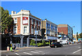
Restaurant on the corner, Fore Street
Still looking very much like a pub, but now trading as the Capital Restaurant.
Image: © Des Blenkinsopp
Taken: 9 Oct 2018
0.05 miles
5
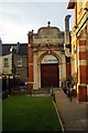
Former Passmore Edwards Library, Fore Street, Edmonton
View of central elevation
Image: © Jim Osley
Taken: 9 Dec 2010
0.11 miles
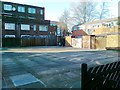
6
Faith House, Fore Street, Edmonton, North London
Image: © Jim Osley
Taken: 9 Dec 2010
0.12 miles
7
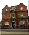
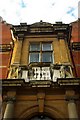
Former Passmore Edwards Library, Fore Street, Edmonton
Edmonton's former Central Library was built to the designs of Maurice B. Adams (1849-1933), an architect most associated with Bedford Park. The building dates from 1897: it closed in 1991, and is currently in use a mosque. For more on John Passmore Edwards and his philanthropic work visit http://www.passmoreedwards.org.uk/
Also illustrated at:
Image
Image
Image: © Jim Osley
Taken: 9 Dec 2010
0.13 miles
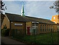
8
Former Passmore Edwards Library, Fore Street, Edmonton
View of entrance to Lending Library, 1931 extension to the main library
Image: © Jim Osley
Taken: 9 Dec 2010
0.13 miles
10
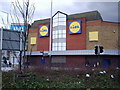
Former site of Regal Cinema
The photograph has been taken at the Angel Edmonton and shows the hideous facade of the supermarket that has now replaced the once Grand 'Regal Cinema' at Upper Edmonton. It demonstrates how many of our historic and dearly loved buildings have been demolished in the face of so called progress. One wonders how the planners could have approved the construction of this building which is a very poor substitute for the previous edifice.
Image: © Alan Swain
Taken: 9 Mar 2008
0.15 miles