IMAGES TAKEN NEAR TO
Langhedge Lane, LONDON, N18 2TJ
Introduction
This page details the photographs taken nearby to Langhedge Lane, N18 2TJ by members of the Geograph project.
The Geograph project started in 2005 with the aim of publishing, organising and preserving representative images for every square kilometre of Great Britain, Ireland and the Isle of Man.

There are currently over 7.5m images from over14,400 individuals and you can help contribute to the project by visiting https://www.geograph.org.uk
Image Map
Images are licensed for reuse under creativecommons.org/licenses/by-sa/2.0
Notes
- Clicking on the map will re-center to the selected point.
- The higher the marker number, the further away the image location is from the centre of the postcode.
Image Listing (32 Images Found)
Images are licensed for reuse under creativecommons.org/licenses/by-sa/2.0
Image
Details
Distance
1
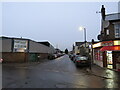
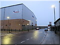
Shaftesbury Road, Edmonton
Shaftesbury Road is a minor road in Edmonton, in the suburbs of north London. This image was taken as darkness was falling on a dull and wet December afternoon.
Image: © Malc McDonald
Taken: 11 Dec 2021
0.07 miles
2
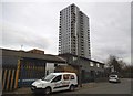
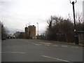
Tower block on Pretoria Road, Edmonton
Image: © David Howard
Taken: 18 Feb 2018
0.10 miles
3
Bridport Road, Edmonton
Crossing the railway by foot
Image: © David Howard
Taken: 18 Feb 2018
0.11 miles
4

The Gilpin's Bell, 50-54 Fore Street, Upper Edmonton, London N18
This rather grim looking building (on the outside) is occupied by a J D Wetherspoon public house known as The Gilpin's Bell. According to their website, the name recalls the Bell Inn, which stood on the west side of Fore Street. That pub was immortalised by William Cowper in his best-selling 18th-century ballad "The Diverting History of John Gilpin". J D Wetherspoon opened this pub in 1998. Being near the Tottenham Hotspur football ground, on match days it is only open to home match day fans.
Image: © P L Chadwick
Taken: 28 Sep 2013
0.13 miles
5
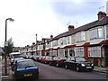
Parkstone Avenue, Upper Edmonton
The development of this area with a network of terraced streets proceeded apace from when the railway opened in the early 1870s until the period between the two World Wars. Parkstone Avenue typifies some of the later housing.
Image: © David Kemp
Taken: 9 May 2006
0.13 miles
6
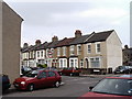
Hawthorn Road, Upper Edmonton
When the Great Eastern Railway began its direct service from Liverpool Street to Enfield Town in 1872 dense grids of terraced streets like this soon began to appear in many of the areas that adjoined the railway such as Tottenham and Edmonton. Within thirty years the population of Edmonton had increased from 14,000 to 62,000. Taken in Shaftesbury Road not far from the railway.
Image: © David Kemp
Taken: 9 May 2006
0.13 miles
7
Pretoria Road North, Edmonton
Pretoria Road North, photographed as darkness fell on a dull and wet December afternoon, is a minor road in the suburbs of north London.
The change in the speed limit, indicated by the 30mph sign, and signs indicating a change to parking restrictions, are a clue that the road crosses a borough boundary here. The area in the foreground is in the London Borough of Haringey but the background is in the London Borough of Enfield.
Image: © Malc McDonald
Taken: 11 Dec 2021
0.14 miles
8

LT's Bar (formerly the Phoenix), 56 Fore Street, Upper Edmonton, London N18
Another local pub which understandably supports the home football team, Tottenham Hotspurs. This pub was for many years known as the Phoenix. It appears as such in the 1911 census. It was also in the 1891 census but no name is given. It was described as a beerhouse. Close examination of the stonework at the front, between the ground and first floors, appears to show carvings of a phoenix. Unfortunately they have been semi-obliterated with dark blue paint.
Image: © P L Chadwick
Taken: 28 Sep 2013
0.14 miles