IMAGES TAKEN NEAR TO
Lyndhurst Road, LONDON, N18 2QA
Introduction
This page details the photographs taken nearby to Lyndhurst Road, N18 2QA by members of the Geograph project.
The Geograph project started in 2005 with the aim of publishing, organising and preserving representative images for every square kilometre of Great Britain, Ireland and the Isle of Man.

There are currently over 7.5m images from over14,400 individuals and you can help contribute to the project by visiting https://www.geograph.org.uk
Image Map
Images are licensed for reuse under creativecommons.org/licenses/by-sa/2.0
Notes
- Clicking on the map will re-center to the selected point.
- The higher the marker number, the further away the image location is from the centre of the postcode.
Image Listing (25 Images Found)
Images are licensed for reuse under creativecommons.org/licenses/by-sa/2.0
Image
Details
Distance
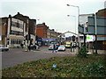
3
Restaurant on the corner, Fore Street
Still looking very much like a pub, but now trading as the Capital Restaurant.
Image: © Des Blenkinsopp
Taken: 9 Oct 2018
0.12 miles
4
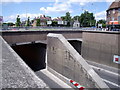
North Circular Road - Tunnel
The North Circular Road (A406) runs in twin bore tunnel under the Hertford Road and railway at The Angel, Edmonton
Image: © John Reeves
Taken: 10 Jul 2009
0.13 miles
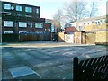
5

Solomon Avenue, Edmonton
Solomon Avenue is a residential road in a modern housing development in Edmonton, in the suburbs of north London.
Image: © Malc McDonald
Taken: 11 Dec 2021
0.14 miles
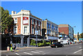
6
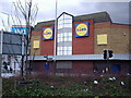
Former site of Regal Cinema
The photograph has been taken at the Angel Edmonton and shows the hideous facade of the supermarket that has now replaced the once Grand 'Regal Cinema' at Upper Edmonton. It demonstrates how many of our historic and dearly loved buildings have been demolished in the face of so called progress. One wonders how the planners could have approved the construction of this building which is a very poor substitute for the previous edifice.
Image: © Alan Swain
Taken: 9 Mar 2008
0.15 miles
7
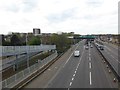
The North Circular Road at Upper Edmonton
This view is from a footbridge looking towards where the North Circular Road passes under Fore Street (A1010) via a short tunnel.
Image: © Marathon
Taken: 12 Apr 2017
0.15 miles
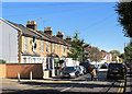
8
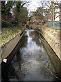
Pymme's Brook, Upper Edmonton
Taken from the footbridge from Angel Place that is parallel with Fore Street, this is in the south-west corner of the grid square. Pymme's Brook is one of the historically significant tributaries of the River Lee.
Image: © Fin Fahey
Taken: 5 Mar 2006
0.16 miles
9
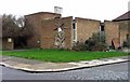
St Mary's Church Centre, Lawrence Road, London N18
Built 1970, architect Brian Freebourne.
Image: © John Salmon
Taken: 23 Jan 2008
0.16 miles