IMAGES TAKEN NEAR TO
Second Avenue, LONDON, N18 2PG
Introduction
This page details the photographs taken nearby to Second Avenue, N18 2PG by members of the Geograph project.
The Geograph project started in 2005 with the aim of publishing, organising and preserving representative images for every square kilometre of Great Britain, Ireland and the Isle of Man.

There are currently over 7.5m images from over14,400 individuals and you can help contribute to the project by visiting https://www.geograph.org.uk
Image Map
Images are licensed for reuse under creativecommons.org/licenses/by-sa/2.0
Notes
- Clicking on the map will re-center to the selected point.
- The higher the marker number, the further away the image location is from the centre of the postcode.
Image Listing (16 Images Found)
Images are licensed for reuse under creativecommons.org/licenses/by-sa/2.0
Image
Details
Distance
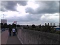
1
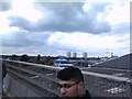
View of high-rise buildings around the Edmonton Green Shopping Centre, viewed from Conduit Way
Looking north-northwest.
Image: © Robert Lamb
Taken: 17 Jun 2012
0.07 miles
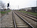
2
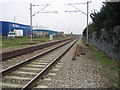
Upper Edmonton: Railway line
Viewed looking in the direction of Angel Road station from the Pegamoid Road foot crossing of the railway, with the A1055 Meridian Way (North - South Route) to the left.
Image: © Nigel Cox
Taken: 30 Jan 2007
0.11 miles
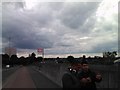
3
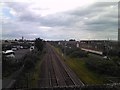
Road and rail at Edmonton
The railway is the Greater Anglia/Stansted Express line towards Hertford East and Stansted Airport. The road is the A1055 Meridian Way, taking traffic from the A406 behind the camera to Ponder's End. Looking north.
Image: © Robert Lamb
Taken: 17 Jun 2012
0.13 miles
4
Industrial estates, Edmonton
Seen from the railway line between Ponders End and Edmonton. On the right is the entrance to the Eley Estate, in Image
Image: © Derek Harper
Taken: 2 Aug 2012
0.17 miles
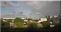
5
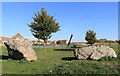
Rocks in the Park
In a recreation ground along Montagu Road, Edmonton.
Image: © Des Blenkinsopp
Taken: 9 Oct 2018
0.17 miles
6
Upper Edmonton: Railway line
Viewed looking in the direction of Ponders End station from the Pegamoid Road foot crossing of the railway, with the A1055 Meridian Way (North - South Route) to the right.
Image: © Nigel Cox
Taken: 30 Jan 2007
0.18 miles
7
View over Edmonton from Conduit Way #2
Looking north-northwest.
Image: © Robert Lamb
Taken: 17 Jun 2012
0.19 miles
8
View over Edmonton from Conduit Way
Looking north-northeast.
Image: © Robert Lamb
Taken: 17 Jun 2012
0.20 miles
9
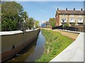
Salmon's Brook in Edmonton (4)
This is a view looking upstream from the Montagu Road culvert showing the new flood defence walls on either side of the brook. Beyond the wall on the left is the Tottenham Park Cemetery. On the right are the housing blocks in Barrowfield Close, which was once the site of the Edmonton Stadium (greyhound racing).
Image: © Nigel Cox
Taken: 5 May 2016
0.21 miles
10
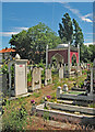
Tottenham Park Cemetery, Upper Edmonton
Used primarily for Muslim burials.
Image: © Jim Osley
Taken: 11 Jun 2017
0.21 miles