IMAGES TAKEN NEAR TO
Rays Avenue, LONDON, N18 2NT
Introduction
This page details the photographs taken nearby to Rays Avenue, N18 2NT by members of the Geograph project.
The Geograph project started in 2005 with the aim of publishing, organising and preserving representative images for every square kilometre of Great Britain, Ireland and the Isle of Man.

There are currently over 7.5m images from over14,400 individuals and you can help contribute to the project by visiting https://www.geograph.org.uk
Image Map
Images are licensed for reuse under creativecommons.org/licenses/by-sa/2.0
Notes
- Clicking on the map will re-center to the selected point.
- The higher the marker number, the further away the image location is from the centre of the postcode.
Image Listing (13 Images Found)
Images are licensed for reuse under creativecommons.org/licenses/by-sa/2.0
Image
Details
Distance
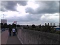
1
View over Edmonton from Conduit Way
Looking north-northeast.
Image: © Robert Lamb
Taken: 17 Jun 2012
0.03 miles
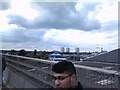
2
View over Edmonton from Conduit Way #2
Looking north-northwest.
Image: © Robert Lamb
Taken: 17 Jun 2012
0.03 miles
3
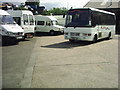
Becket Road, Edmonton
Becket Road is a very short street (not much longer than 15 metres) which leads to a small industrial estate owned by the London Borough of Enfield in which the units are grouped around a large yard. Among its tenants are a coach company, whose vehicles are seen here, a printer and a furniture manufacturer.
The pile of cars to the left is in the scrapyard next door.
Image: © Rob Candlish
Taken: 23 May 2005
0.08 miles
4
View of Cheshire and Shropshire Houses from Conduit Way
Looking north-northwest.
Image: © Robert Lamb
Taken: 17 Jun 2012
0.09 miles
5
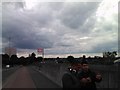
View of high-rise buildings around the Edmonton Green Shopping Centre, viewed from Conduit Way
Looking north-northwest.
Image: © Robert Lamb
Taken: 17 Jun 2012
0.14 miles
6
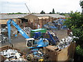
Edmonton: Scrap metal merchants
With the current high cost of commodities scrap metal merchants are having a busy time. However a great deal of care has to be taken to sort through the various types of metal that come their way and here the dealer has neatly separated these out.
Image: © Nigel Cox
Taken: 10 Jun 2008
0.19 miles
7
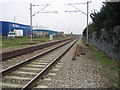
Upper Edmonton: Railway line
Viewed looking in the direction of Angel Road station from the Pegamoid Road foot crossing of the railway, with the A1055 Meridian Way (North - South Route) to the left.
Image: © Nigel Cox
Taken: 30 Jan 2007
0.20 miles
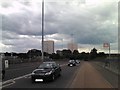
8
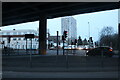
Under the North Circular at The Angel. Edmonton
Looking towards Montagu Road
Image: © David Howard
Taken: 13 Feb 2021
0.21 miles
9
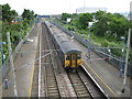
Edmonton: Angel Road railway station
Angel Road has to be one of the least used railway stations in London. It is nowhere near any houses, near only a few industrial premises and demands a walk along busy main roads to its only point of access. This is reflected in the number of trains that stop here during the day, about 10 during the morning rush-hour and then about 10 again during the evening rush-hour with a six hour gap in between. Yet oddly the station pre-dated all the general growth of Edmonton and was built as a country station where Angel Road, now the North Circular, crossed the line.
Here a southbound National Express train, not stopping of course, runs through the deserted station. For the train-spotters the leading unit was 317 732.
Image: © Nigel Cox
Taken: 10 Jun 2008
0.21 miles
10
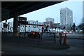
Under the North Circular at The Angel. Edmonton
Image: © David Howard
Taken: 13 Feb 2021
0.21 miles