IMAGES TAKEN NEAR TO
Amersham Avenue, LONDON, N18 1DZ
Introduction
This page details the photographs taken nearby to Amersham Avenue, N18 1DZ by members of the Geograph project.
The Geograph project started in 2005 with the aim of publishing, organising and preserving representative images for every square kilometre of Great Britain, Ireland and the Isle of Man.

There are currently over 7.5m images from over14,400 individuals and you can help contribute to the project by visiting https://www.geograph.org.uk
Image Map (Loading...)


Getting Data...Please wait
Leaflet Map data © OpenStreetMap
Images are licensed for reuse under creativecommons.org/licenses/by-sa/2.0
Notes
- Clicking on the map will re-center to the selected point.
- The higher the marker number, the further away the image location is from the centre of the postcode.
Image Listing (23 Images Found)
Images are licensed for reuse under creativecommons.org/licenses/by-sa/2.0
Image
Details
Distance
1
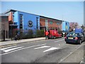
Wilbury Primary School, Weir Hall Road
Contrasting nicely with the post office van. There are two primary schools on Weir Hall Road - this one is in Enfield http://www.wilbury.enfield.sch.uk/ and the one opposite the Weymarks is in Haringey.
Image: © Christine Johnstone
Taken: 23 Mar 2012
0.08 miles
2
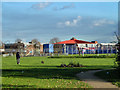
Weir Hall Park and Wilbury Primary School
The striking roof of one of the school blocks is seen across this fairly small green area.
Image: © Robin Webster
Taken: 11 Nov 2012
0.10 miles
3

Lansbury Avenue
From its junction with Weir Hall Road.
Image: © Christine Johnstone
Taken: 23 Mar 2012
0.11 miles
4
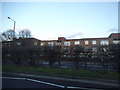
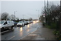
Flats on Great Cambridge Road, Edmonton
Image: © David Howard
Taken: 7 Jan 2014
0.15 miles
5
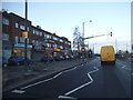
Shops on Great Cambridge Road, Tottenham
Image: © David Howard
Taken: 7 Jan 2014
0.15 miles
7
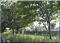
Allotments by Great Cambridge Road, Edmonton
Image: © David Howard
Taken: 26 May 2018
0.16 miles
8
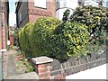
Caterpillar hedge on Great Cambridge Road, Edmonton
Image: © David Howard
Taken: 26 May 2018
0.17 miles
9
Wilbury Way, N18
A block of houses on the north side of the road.
Image: © Christine Johnstone
Taken: 23 Mar 2012
0.17 miles
10
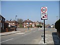
20 mph zone, Weir Hall Road
At the junction with Barclay Road.
Image: © Christine Johnstone
Taken: 23 Mar 2012
0.17 miles