IMAGES TAKEN NEAR TO
Empire Avenue, LONDON, N18 1AP
Introduction
This page details the photographs taken nearby to Empire Avenue, N18 1AP by members of the Geograph project.
The Geograph project started in 2005 with the aim of publishing, organising and preserving representative images for every square kilometre of Great Britain, Ireland and the Isle of Man.

There are currently over 7.5m images from over14,400 individuals and you can help contribute to the project by visiting https://www.geograph.org.uk
Image Map
Images are licensed for reuse under creativecommons.org/licenses/by-sa/2.0
Notes
- Clicking on the map will re-center to the selected point.
- The higher the marker number, the further away the image location is from the centre of the postcode.
Image Listing (7 Images Found)
Images are licensed for reuse under creativecommons.org/licenses/by-sa/2.0
Image
Details
Distance
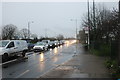
3
Allotments by Great Cambridge Road, Edmonton
Image: © David Howard
Taken: 26 May 2018
0.21 miles
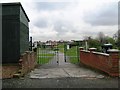
5
Pasteur Gardens at the junction of Great Cambridge Road
Image: © David Howard
Taken: 9 Mar 2020
0.24 miles
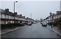
6
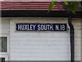
Sign for Huxley South, Edmonton
The terraced houses along the road each have names per set, Huxley Sayze, Huxley South, Victor Villas which I couldn't find although they are all in a row and a couple more.
Image: © David Howard
Taken: 26 May 2018
0.25 miles