IMAGES TAKEN NEAR TO
Napier Grove, LONDON, N1 7HX
Introduction
This page details the photographs taken nearby to Napier Grove, N1 7HX by members of the Geograph project.
The Geograph project started in 2005 with the aim of publishing, organising and preserving representative images for every square kilometre of Great Britain, Ireland and the Isle of Man.

There are currently over 7.5m images from over14,400 individuals and you can help contribute to the project by visiting https://www.geograph.org.uk
Image Map
Images are licensed for reuse under creativecommons.org/licenses/by-sa/2.0
Notes
- Clicking on the map will re-center to the selected point.
- The higher the marker number, the further away the image location is from the centre of the postcode.
Image Listing (443 Images Found)
Images are licensed for reuse under creativecommons.org/licenses/by-sa/2.0
Image
Details
Distance


8
Looking down Godwin Close from Shepherdess Walk
Looking east-northeast.
Image: © Robert Lamb
Taken: 10 Apr 2011
0.04 miles

10
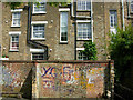
Shepherdess Walk, Hoxton
The backs of houses on Shepherdess Walk are seen here from the open space that runs alongside Wenlock Road, north of Sturt Street.
Image: © Stephen McKay
Taken: 11 May 2009
0.04 miles