IMAGES TAKEN NEAR TO
Parr Street, LONDON, N1 7GW
Introduction
This page details the photographs taken nearby to Parr Street, N1 7GW by members of the Geograph project.
The Geograph project started in 2005 with the aim of publishing, organising and preserving representative images for every square kilometre of Great Britain, Ireland and the Isle of Man.

There are currently over 7.5m images from over14,400 individuals and you can help contribute to the project by visiting https://www.geograph.org.uk
Image Map
Images are licensed for reuse under creativecommons.org/licenses/by-sa/2.0
Notes
- Clicking on the map will re-center to the selected point.
- The higher the marker number, the further away the image location is from the centre of the postcode.
Image Listing (338 Images Found)
Images are licensed for reuse under creativecommons.org/licenses/by-sa/2.0
Image
Details
Distance

3
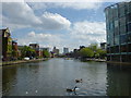
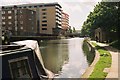
City Basin
Redeveloped backwater on the Regent's Canal, Islington.
Image: © dg
Taken: 2 May 2005
0.05 miles
4
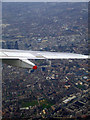
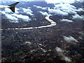
Shoreditch and the Thames from the air
Shoreditch Park is at the bottom of the photo. The Gerkhin building can just be seen to the left edge, above the wing, with HMS Belfast moored in the Thames beyond.
The aircraft (a BA flight from Glasgow) was banking sharply to the right at this point, for final approach to Heathrow from the east.
Image: © Thomas Nugent
Taken: 24 Jan 2011
0.05 miles
5
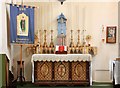
Holy Trinity, Shepherdess Walk, Hoxton - Lady chapel
Image: © John Salmon
Taken: 9 Oct 2011
0.05 miles
6
London and the Thames from the air
Looking towards the London Eye and Westminster, with The Shard building under construction on the extreme left. Viewed from a Heathrow bound flight from Glasgow, somewhere near Stoke Newington.
Image: © Thomas Nugent
Taken: 9 Oct 2011
0.05 miles
8
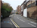
Regent's Canal east of New North Road
Looking west along Regent's Canal towards New North Road bridge.
Image: © Pierre Terre
Taken: 7 May 2005
0.06 miles
9
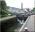
Sturt's Lock, Regent Canal
details: http://canalplan.eu/gazetteer/2pn9
Image: © Paul Gillett
Taken: 31 May 2014
0.06 miles
10
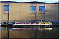
Dutch barge, Regent's Canal
Oliekop (oil cap) was first registered in 1927, and used to deliver oil.
Image: © Ian Taylor
Taken: 3 Mar 2020
0.06 miles