IMAGES TAKEN NEAR TO
Wharf Road, LONDON, N1 7GQ
Introduction
This page details the photographs taken nearby to Wharf Road, N1 7GQ by members of the Geograph project.
The Geograph project started in 2005 with the aim of publishing, organising and preserving representative images for every square kilometre of Great Britain, Ireland and the Isle of Man.

There are currently over 7.5m images from over14,400 individuals and you can help contribute to the project by visiting https://www.geograph.org.uk
Image Map
Images are licensed for reuse under creativecommons.org/licenses/by-sa/2.0
Notes
- Clicking on the map will re-center to the selected point.
- The higher the marker number, the further away the image location is from the centre of the postcode.
Image Listing (599 Images Found)
Images are licensed for reuse under creativecommons.org/licenses/by-sa/2.0
Image
Details
Distance
3
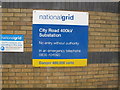
Sign for City Road 400kV substation
400kV power lines in this area are in tunnels. There are lower voltage substations nearby.
Image: © David Hawgood
Taken: 3 May 2018
0.03 miles
4
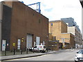
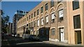
City Road 400kV substation, Wharf Road, Islington
The white van is parked in front of another part of the National Grid site, the 400kV substation is in the lighter coloured brick building beyond. Beyond that again is a new apartment block. Image shows the sign for the substation.
Image: © David Hawgood
Taken: 3 May 2018
0.03 miles
5
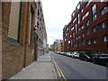
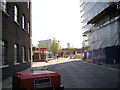
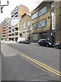
Wharf Road, N1
Redevelopment of the canal basins on either side of Wharf Road has populated it with a mixture of new flats and converted warehouses.
Image: © Christopher Hilton
Taken: 14 Sep 2016
0.03 miles
6
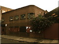
Waiting to be converted to Luxury Flats
Image: © Chris Whippet
Taken: 6 Aug 2008
0.04 miles
7
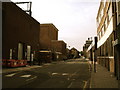
McDonald's in Wharf Road
This McDonald's is very special as, not only does it appear to be standing on the boundary of the parish of St Leonard Shoreditch that the plaque in Image mentions, it is also right on the border between two gridsquares, TQ3282 and TQ3283, as well as the border between the London Boroughs of Hackney and Islington! How's that for a boundary record? Looking south from Wharf Road.
Image: © Robert Lamb
Taken: 10 Apr 2011
0.05 miles
8
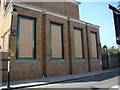
Mosaic-style windows on the National Grid's City Road substation
Looking north-northwest.
Image: © Robert Lamb
Taken: 10 Apr 2011
0.05 miles
9
Art galleries in Wharf Road, Hackney side
I was visiting an exhibition of abstract art by female artists in the Victoria Miro gallery, which has the two floors of a former warehouse. The exhibition continued onto the third floor above the adjoining Parasol Unit. The two share a garden with the end of Wenlock canal basin. In Wharf Road beyond the galleries are modern apartment blocks with balconies that overhang the pavement.
Image: © David Hawgood
Taken: 3 May 2018
0.05 miles
10
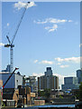
City Road Basin
City Road Basin is one of two running off the Regent's Canal just to the east of City Road Lock; in this view there is a backdrop of buildings along City Road and beyond.
Image: © Stephen McKay
Taken: 20 Oct 2010
0.05 miles