IMAGES TAKEN NEAR TO
Parkhurst Road, LONDON, N17 9RD
Introduction
This page details the photographs taken nearby to Parkhurst Road, N17 9RD by members of the Geograph project.
The Geograph project started in 2005 with the aim of publishing, organising and preserving representative images for every square kilometre of Great Britain, Ireland and the Isle of Man.

There are currently over 7.5m images from over14,400 individuals and you can help contribute to the project by visiting https://www.geograph.org.uk
Image Map
Images are licensed for reuse under creativecommons.org/licenses/by-sa/2.0
Notes
- Clicking on the map will re-center to the selected point.
- The higher the marker number, the further away the image location is from the centre of the postcode.
Image Listing (89 Images Found)
Images are licensed for reuse under creativecommons.org/licenses/by-sa/2.0
Image
Details
Distance
1
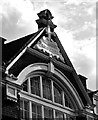
Tottenham : Parkhurst Road school gable plaque
The former Parkhurst Road School, built and opened in 1910, is currently the home of Mulberry Primary School.
Image: © Jim Osley
Taken: 22 May 2020
0.08 miles
3
Prince of Wales, High Road N17
At the junction with Scotland Green
Image: © Robin Sones
Taken: 11 Aug 2011
0.11 miles
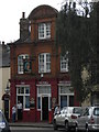
5
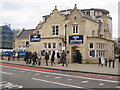
Pride of Tottenham
Pride of Tottenham pub on High Road.
Image: © Philip Halling
Taken: 7 Jan 2012
0.11 miles
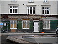
6
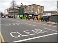
High Road, Tottenham
Evidence of the August 2012 riots on High Road, Tottenham.
Image: © Philip Halling
Taken: 7 Jan 2012
0.11 miles
9
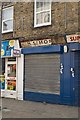
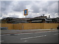
Disused shop, Scotland Green, Tottenham Green
Image: © Jim Osley
Taken: 5 May 2014
0.12 miles
10
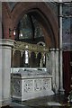
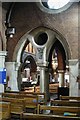
St Mary, Lansdowne Road, London N17 - Tomb
Image: © John Salmon
Taken: 4 Aug 2003
0.12 miles