IMAGES TAKEN NEAR TO
Tamar Way, LONDON, N17 9HF
Introduction
This page details the photographs taken nearby to Tamar Way, N17 9HF by members of the Geograph project.
The Geograph project started in 2005 with the aim of publishing, organising and preserving representative images for every square kilometre of Great Britain, Ireland and the Isle of Man.

There are currently over 7.5m images from over14,400 individuals and you can help contribute to the project by visiting https://www.geograph.org.uk
Image Map
Images are licensed for reuse under creativecommons.org/licenses/by-sa/2.0
Notes
- Clicking on the map will re-center to the selected point.
- The higher the marker number, the further away the image location is from the centre of the postcode.
Image Listing (88 Images Found)
Images are licensed for reuse under creativecommons.org/licenses/by-sa/2.0
Image
Details
Distance
1
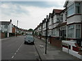
Holcombe Road N17
Near junction of Dawlish Road. Parking is by permit only around here, because it is close to Tottenham Hale railway station with its fast trains to Central London and Stansted Airport.
Image: © Danny P Robinson
Taken: 18 Jun 2006
0.08 miles
2
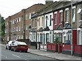
Dawlish Road N17
A side street in Tottenham.
Image: © Danny P Robinson
Taken: 18 Jun 2006
0.08 miles
3
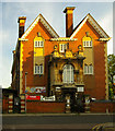
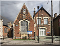
Former school building, Tottenham
The erstwhile home of Tottenham Grammar School. Built to the designs of Middlesex County Council architect H.G. Crothall, 1908-1910.
Image: © Jim Osley
Taken: 3 Jun 2013
0.10 miles
4
The Good Shepherd, Mitchley Road, Tottenham
Image: © John Salmon
Taken: 28 Sep 2017
0.10 miles
5
The Good Shepherd, Mitchley Road, Tottenham Hale, London N17
Image: © John Salmon
Taken: 18 Sep 2017
0.11 miles
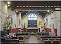
6
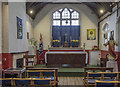
The Good Shepherd, Mitchley Road, Tottenham - Chancel
Image: © John Salmon
Taken: 28 Sep 2017
0.11 miles
7
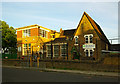
Holy Trinity Primary School, Tottenham
Victorian school building with unsympathetic modern extension.
Image: © Jim Osley
Taken: 3 Jun 2013
0.12 miles
8
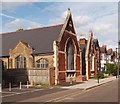
Tottenham : Church of the Good Shepherd
Location: Mitchley Road, London N17. Re-opened in 2010. Built as a mission hall of the nearby St Mary's Church, Tottenham, in the 1890s - https://www.british-history.ac.uk/vch/middx/vol5/pp348-355. The church bears a plaque to one Ralph Joscelyne 1899-1909, "who was shot on this spot during the Tottenham Outrage on Jan. 23rd, 1909".
More on the Tottenham Outrage may be found at this https://en.wikipedia.org/wiki/Tottenham_Outrage.
Image: © Jim Osley
Taken: 22 May 2020
0.12 miles
9
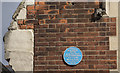
The Good Shepherd, Minchley Road, Tottenham Hale, London N17 - Blue plaque
Image: © John Salmon
Taken: 18 Sep 2017
0.12 miles
10
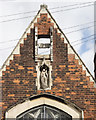
The Good Shepherd, Minchley Road, Tottenham Hale, London N17 - Exterior detail
Image: © John Salmon
Taken: 18 Sep 2017
0.12 miles