IMAGES TAKEN NEAR TO
Holcombe Road, LONDON, N17 9AB
Introduction
This page details the photographs taken nearby to Holcombe Road, N17 9AB by members of the Geograph project.
The Geograph project started in 2005 with the aim of publishing, organising and preserving representative images for every square kilometre of Great Britain, Ireland and the Isle of Man.

There are currently over 7.5m images from over14,400 individuals and you can help contribute to the project by visiting https://www.geograph.org.uk
Image Map
Images are licensed for reuse under creativecommons.org/licenses/by-sa/2.0
Notes
- Clicking on the map will re-center to the selected point.
- The higher the marker number, the further away the image location is from the centre of the postcode.
Image Listing (79 Images Found)
Images are licensed for reuse under creativecommons.org/licenses/by-sa/2.0
Image
Details
Distance
1
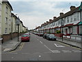
Ladysmith Road N17
A side road typical of the ones in this part of Tottenham.
Image: © Danny P Robinson
Taken: 18 Jun 2006
0.05 miles
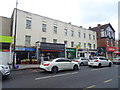
2
Holcombe Road N17
Near junction of Dawlish Road. Parking is by permit only around here, because it is close to Tottenham Hale railway station with its fast trains to Central London and Stansted Airport.
Image: © Danny P Robinson
Taken: 18 Jun 2006
0.05 miles
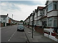
3
Dawlish Road N17
A side street in Tottenham.
Image: © Danny P Robinson
Taken: 18 Jun 2006
0.05 miles
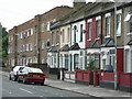
4
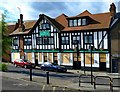
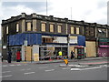
Tottenham : "The Beehive" public house
Built 1927. Grade II listed. https://historicengland.org.uk/listing/the-list/list-entry/1393614. Currently boarded to prevent intrusion during the COVID-19 outbreak.
Image: © Jim Osley
Taken: 25 May 2020
0.06 miles
5
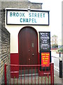
Brook Street Chapel Tottenham
The sign says that at 11 a.m. there is the breaking of bread which sounds so comforting to me.
Image: © John Kingdon
Taken: 1 Nov 2018
0.07 miles
6
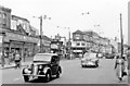
London (Tottenham), 1955
View northward on Tottenham High Road (A1010), at Bruce Grove and its station on the left. (See also Image).
Image: © Ben Brooksbank
Taken: 13 Jul 1955
0.07 miles
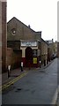
8
William Hill, High Road N17
At the junction of Stoneleigh Road. Post riot damage
Image: © Robin Sones
Taken: 11 Aug 2011
0.08 miles
9
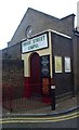
Brook Street Chapel, Tottenham - view of entrance
Building dates from 1839
Image: © Jim Osley
Taken: 9 Dec 2010
0.09 miles