IMAGES TAKEN NEAR TO
N17 8LU
Introduction
This page details the photographs taken nearby to N17 8LU by members of the Geograph project.
The Geograph project started in 2005 with the aim of publishing, organising and preserving representative images for every square kilometre of Great Britain, Ireland and the Isle of Man.

There are currently over 7.5m images from over14,400 individuals and you can help contribute to the project by visiting https://www.geograph.org.uk
Image Map
Images are licensed for reuse under creativecommons.org/licenses/by-sa/2.0
Notes
- Clicking on the map will re-center to the selected point.
- The higher the marker number, the further away the image location is from the centre of the postcode.
Image Listing (85 Images Found)
Images are licensed for reuse under creativecommons.org/licenses/by-sa/2.0
Image
Details
Distance
1
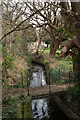
Tottenham : Moselle river, Tottenham Cemetery
Description of the river at this https://www.londonslostrivers.com/river-moselle.html.
Image: © Jim Osley
Taken: 15 Mar 2022
0.02 miles
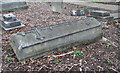
2
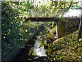
The Moselle in Tottenham Cemetery
The bridge is internal to the cemetery. The view is taken from a bridge on a railed footpath that bisects the cemetery. The brook name has nothing to do with the well-known continental river, but comes from the same roots as Muswell Hill.
Image: © Robin Webster
Taken: 11 Nov 2012
0.04 miles
3
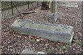
All Hallows, Tottenham - Graveyard
Grave of William Butterfield - Architect
Image: © John Salmon
Taken: 2 Mar 2013
0.07 miles
4
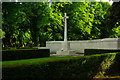
War memorial, Tottenham Cemetery
Grade II listed - described at this https://historicengland.org.uk/listing/the-list/list-entry/1084328
Image: © Jim Osley
Taken: 3 Jun 2013
0.08 miles
6

Pair of chapels, Tottenham Cemetery (1856-57)
Architect: George Prichett. Grade II listed building, described at this https://historicengland.org.uk/listing/the-list/list-entry/1084330
Image: © Jim Osley
Taken: 3 Jun 2013
0.11 miles
7

Tottenham Cemetery The Dark and the Light
A funeral was over and the dark skies seemed about to douse the light. It seemed a perfect metaphor for death.
Image: © John Kingdon
Taken: 15 Jan 2020
0.12 miles
8
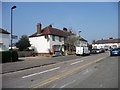
Barkham Road, Tottenham
From the junction with White Hart Lane.
Image: © Christine Johnstone
Taken: 23 Mar 2012
0.12 miles
9
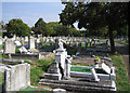
Tottenham Cemetery
The Cemetery was opened in 1858 and covers about 25 hectares, most of them in this kilometre grid square.
Image: © Nigel Cox
Taken: 6 Sep 2006
0.12 miles
10

White Hart Lane, Tottenham
Houses on the north side.
Image: © Christine Johnstone
Taken: 23 Mar 2012
0.14 miles