IMAGES TAKEN NEAR TO
Cannon Road, LONDON, N17 8FA
Introduction
This page details the photographs taken nearby to Cannon Road, N17 8FA by members of the Geograph project.
The Geograph project started in 2005 with the aim of publishing, organising and preserving representative images for every square kilometre of Great Britain, Ireland and the Isle of Man.

There are currently over 7.5m images from over14,400 individuals and you can help contribute to the project by visiting https://www.geograph.org.uk
Image Map
Images are licensed for reuse under creativecommons.org/licenses/by-sa/2.0
Notes
- Clicking on the map will re-center to the selected point.
- The higher the marker number, the further away the image location is from the centre of the postcode.
Image Listing (44 Images Found)
Images are licensed for reuse under creativecommons.org/licenses/by-sa/2.0
Image
Details
Distance
1
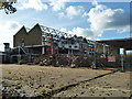
Demolition site, Tottenham
Most recently a car mat factory.
Image: © Robin Webster
Taken: 11 Nov 2012
0.01 miles
3
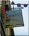
The Coach & Horses (2) - sign, 862 High Road, Tottenham, London N17
The rather faded sign illustrates the pub's name.
Image
Image: © P L Chadwick
Taken: 28 Sep 2013
0.06 miles
4
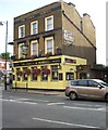
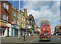
The Coach & Horses (1), 862 High Road, Tottenham, London N17
This old public house is located on the corner of High Road (part of the A1010) and Brantwood Road. It dates from 1826 and was formerly a Truman house but today it is a free house owned by Woolwich Taverns.
Image
Image: © P L Chadwick
Taken: 28 Sep 2013
0.06 miles
6
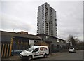
Tower block on Pretoria Road, Edmonton
Image: © David Howard
Taken: 18 Feb 2018
0.10 miles
7
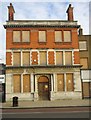
Former Tottenham and Edmonton Dispensary
This is one of many buildings in this part of Tottenham that are closed and boarded up, perhaps to be demolished, as part of the Tottenham Hotspur football ground redevelopment project.
Image: © Jim Osley
Taken: 9 Dec 2010
0.10 miles
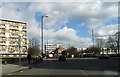
8
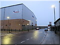
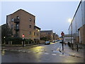
Pretoria Road North, Edmonton
Pretoria Road North, photographed as darkness fell on a dull and wet December afternoon, is a minor road in the suburbs of north London.
The change in the speed limit, indicated by the 30mph sign, and signs indicating a change to parking restrictions, are a clue that the road crosses a borough boundary here. The area in the foreground is in the London Borough of Haringey but the background is in the London Borough of Enfield.
Image: © Malc McDonald
Taken: 11 Dec 2021
0.10 miles
9
Commercial Road, Tottenham
Commercial Road, in the suburbs of north London, runs along the northern boundary of the London Borough of Haringey. The road and buildings to the left are in Haringey, but the warehouse to the right of the image is in the London Borough of Enfield. "No entry" signs indicate that the road is a one-way street.
This image was taken as darkness fell on a wet and gloomy December afternoon.
Image: © Malc McDonald
Taken: 11 Dec 2021
0.11 miles
10
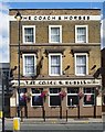
Tottenham : "The Coach & Horses" public house
Image: © Jim Osley
Taken: 7 Aug 2019
0.11 miles