IMAGES TAKEN NEAR TO
College Park Road, LONDON, N17 8DY
Introduction
This page details the photographs taken nearby to College Park Road, N17 8DY by members of the Geograph project.
The Geograph project started in 2005 with the aim of publishing, organising and preserving representative images for every square kilometre of Great Britain, Ireland and the Isle of Man.

There are currently over 7.5m images from over14,400 individuals and you can help contribute to the project by visiting https://www.geograph.org.uk
Image Map
Images are licensed for reuse under creativecommons.org/licenses/by-sa/2.0
Notes
- Clicking on the map will re-center to the selected point.
- The higher the marker number, the further away the image location is from the centre of the postcode.
Image Listing (52 Images Found)
Images are licensed for reuse under creativecommons.org/licenses/by-sa/2.0
Image
Details
Distance
1
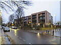
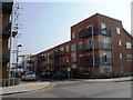
Modern apartment block, Tottenham
A modern apartment block on Pretoria Road in Tottenham, in the suburbs of north London. This image was taken as darkness fell on a dull and damp December afternoon.
Image: © Malc McDonald
Taken: 11 Dec 2021
0.03 miles
2
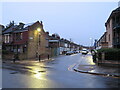
Durban Road, Tottenham
Durban Road is a residential road in Tottenham, in the suburbs of north London. This image was taken as darkness was falling in a dull and wet December afternoon.
Image: © Malc McDonald
Taken: 11 Dec 2021
0.06 miles
3
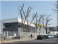
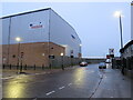
Haringey Sixth Form Centre, Tottenham
'A totally inclusive learning environment' http://www.haringey6.ac.uk/ .
Image: © Christine Johnstone
Taken: 23 Mar 2012
0.10 miles
4
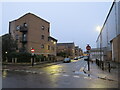
Commercial Road, Tottenham
Commercial Road, in the suburbs of north London, runs along the northern boundary of the London Borough of Haringey. The road and buildings to the left are in Haringey, but the warehouse to the right of the image is in the London Borough of Enfield. "No entry" signs indicate that the road is a one-way street.
This image was taken as darkness fell on a wet and gloomy December afternoon.
Image: © Malc McDonald
Taken: 11 Dec 2021
0.11 miles
5
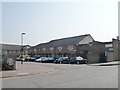
Academia Way, Tottenham
The yellow-roofed building is a sixth form college.
Image: © Christine Johnstone
Taken: 23 Mar 2012
0.11 miles
6
The former Trafalgar Christian Centre
A boarded-up church at the southern end of Queen Street, Tottenham, N17.
Image: © Christine Johnstone
Taken: 23 Mar 2012
0.12 miles
7
Pretoria Road North, Edmonton
Pretoria Road North, photographed as darkness fell on a dull and wet December afternoon, is a minor road in the suburbs of north London.
The change in the speed limit, indicated by the 30mph sign, and signs indicating a change to parking restrictions, are a clue that the road crosses a borough boundary here. The area in the foreground is in the London Borough of Haringey but the background is in the London Borough of Enfield.
Image: © Malc McDonald
Taken: 11 Dec 2021
0.12 miles
8
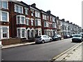
White Hart Lane, Tottenham
Late Victorian three storey terraced houses are an unusual sight in this part of Tottenham.
Image: © Christine Johnstone
Taken: 23 Mar 2012
0.12 miles
9
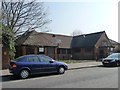
Hebden Terrace, off Bull Lane
A row of houses squeezed in at the edge of an industrial area.
Image: © Christine Johnstone
Taken: 23 Mar 2012
0.12 miles
10

Train by Pretoria Road, Tottenham
Leaving White Hart Lane Station heading to Edmonton
Image: © David Howard
Taken: 18 Feb 2018
0.13 miles