IMAGES TAKEN NEAR TO
Cedar Road, LONDON, N17 8BF
Introduction
This page details the photographs taken nearby to Cedar Road, N17 8BF by members of the Geograph project.
The Geograph project started in 2005 with the aim of publishing, organising and preserving representative images for every square kilometre of Great Britain, Ireland and the Isle of Man.

There are currently over 7.5m images from over14,400 individuals and you can help contribute to the project by visiting https://www.geograph.org.uk
Image Map (115 Images)


Leaflet Map data © OpenStreetMap
Images are licensed for reuse under creativecommons.org/licenses/by-sa/2.0
Notes
- Clicking on the map will re-center to the selected point.
- The higher the marker number, the further away the image location is from the centre of the postcode.
Image Listing (115 Images Found)
Images are licensed for reuse under creativecommons.org/licenses/by-sa/2.0
Image
Details
Distance
1
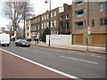
Burned out presmises
Burned out premises on High Road Tottenham, presumably as a result of the August 2011 riots.
Image: © Philip Halling
Taken: 7 Jan 2012
0.02 miles
2
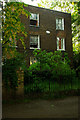
Moselle House, Tottenham
18th century Grade II listed building.
Image: © Jim Osley
Taken: 3 Jun 2013
0.03 miles
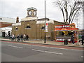
3
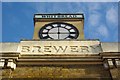
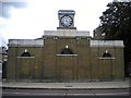
Clockface, former Bell Brewery, Tottenham
Gripper Brothers' Bell Brewery was established in Tottenham in 1760 and was acquired by Whitbread and Company in 1896. Whitbread turned it into a bottling depot later the same year.
Image: © Jim Osley
Taken: 9 Dec 2010
0.04 miles
4
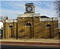
Former Bell Brewery building, Tottenham
Gripper Brothers' Bell Brewery was established in Tottenham in 1760 and was acquired by Whitbread and Company in 1896. Whitbread turned it into a bottling depot later the same year.
Image: © Jim Osley
Taken: 9 Dec 2010
0.04 miles
5
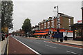
Tottenham High Road
A surprising lull in the traffic. This is the A1010.
Image: © Bill Boaden
Taken: 13 Nov 2010
0.05 miles
7

Site of a demolished building
This building was destroyed by fire in the riots of 9th August 2011 and was demolished as a result.
Image: © Philip Halling
Taken: 7 Jan 2012
0.07 miles
8
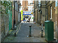
Argyle Passage, N17
This connects the High Street with Argyle Road (behind the camera) for pedestrians.
Image: © Robin Webster
Taken: 11 Nov 2012
0.07 miles
9
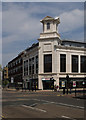
Rebuilt London Co-operative Society department store, Tottenham
The original building Image] was destroyed in the Tottenham riot of August 2011.
Image: © Jim Osley
Taken: 5 Jan 2014
0.07 miles
10
Former Bell Brewery building, Tottenham
Former Bell Brewery building on High Road, Tottenham.
Image: © Philip Halling
Taken: 7 Jan 2012
0.07 miles