IMAGES TAKEN NEAR TO
Spottons Grove, LONDON, N17 7JB
Introduction
This page details the photographs taken nearby to Spottons Grove, N17 7JB by members of the Geograph project.
The Geograph project started in 2005 with the aim of publishing, organising and preserving representative images for every square kilometre of Great Britain, Ireland and the Isle of Man.

There are currently over 7.5m images from over14,400 individuals and you can help contribute to the project by visiting https://www.geograph.org.uk
Image Map
Images are licensed for reuse under creativecommons.org/licenses/by-sa/2.0
Notes
- Clicking on the map will re-center to the selected point.
- The higher the marker number, the further away the image location is from the centre of the postcode.
Image Listing (18 Images Found)
Images are licensed for reuse under creativecommons.org/licenses/by-sa/2.0
Image
Details
Distance
1
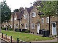
Tower Gardens Conservation Area : housing terrace, Gospatrick Road
Image: © Jim Osley
Taken: 12 May 2020
0.09 miles
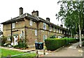
2
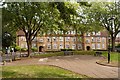
Topham Square, Tower Gardens Estate, Tottenham
The flats in Topham Square were the last development of the Tower Gardens Estate, completed in 1924 to the designs of London County Council architect George Topham Forrest.
Image: © Jim Osley
Taken: 29 Sep 2016
0.12 miles
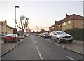
3

Rivulet Road, Tottenham
This is the centre of a council estate with the through routes blocked to the A10
Image: © David Howard
Taken: 20 Jan 2016
0.15 miles
4
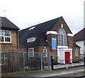
Trinity African Methodist Episcopal Zion Church, Tower Gardens Estate
Image: © Jim Osley
Taken: 30 Jan 2018
0.18 miles
5
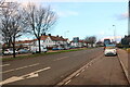
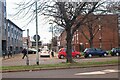
The Crossway, Wood Green
This is just west of the Tottenham border
Image: © David Howard
Taken: 20 Jan 2016
0.19 miles
7
Gospatrick Road, Tottenham
The Tower Gardens Estate was London's first garden suburb. For more information, see Image
Image: © Mary and Angus Hogg
Taken: 19 Jun 2019
0.20 miles
8
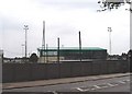
Coles Park football ground, White Hart Lane, Tottenham
Despite being called 'White Hart Lane', the Tottenham Hotspur ground is not geographically in White Hart Lane at all but in nearby Park Lane Image But football is nevertheless played in the real White Hart Lane at Coles Park where the Haringey Borough Football club has its ground.
Image: © David Kemp
Taken: 9 May 2006
0.21 miles
9
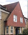
Tower Gardens Conservation Area : tile-hung house, Wateville Road
Image: © Jim Osley
Taken: 12 May 2020
0.22 miles
10
Roundway, Tottenham
Looking towards Granville Road
Image: © David Howard
Taken: 23 Jan 2021
0.22 miles