IMAGES TAKEN NEAR TO
Fryatt Road, LONDON, N17 7BN
Introduction
This page details the photographs taken nearby to Fryatt Road, N17 7BN by members of the Geograph project.
The Geograph project started in 2005 with the aim of publishing, organising and preserving representative images for every square kilometre of Great Britain, Ireland and the Isle of Man.

There are currently over 7.5m images from over14,400 individuals and you can help contribute to the project by visiting https://www.geograph.org.uk
Image Map
Images are licensed for reuse under creativecommons.org/licenses/by-sa/2.0
Notes
- Clicking on the map will re-center to the selected point.
- The higher the marker number, the further away the image location is from the centre of the postcode.
Image Listing (24 Images Found)
Images are licensed for reuse under creativecommons.org/licenses/by-sa/2.0
Image
Details
Distance
1
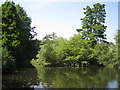
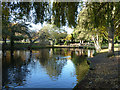
Tottenham Cemetery lake
This lake is at the western edge of the cemetery and is fed by a natural spring.
Image: © Nigel Cox
Taken: 6 Sep 2006
0.03 miles
2
Tottenham: Jellicoe Road, N17
Jellicoe Road is named after John Rushworth Jellicoe, 1st Earl Jellicoe, who was a Royal Navy Admiral of the Fleet during the First World War. Joining Jellicoe Road is Cavell Road remembering another First World War hero, the nurse Edith Cavell. So these houses probably date from the early 1920s.
Image: © Nigel Cox
Taken: 6 Sep 2006
0.04 miles
3
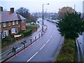
Great Cambridge Road A10 Tottenham
Southbound carriageway as viewed from the pedestrian bridge.
Image: © Geoff Dent
Taken: 20 Nov 2007
0.09 miles
4
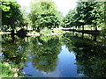
The lake in the Garden of Peace in Tottenham Cemetery
Tottenham Cemetery was opened in 1858. The Garden of Peace covers about a quarter of the cemetery, the centrepiece being a sizeable lake, fed by a natural spring.
Image: © Marathon
Taken: 23 Sep 2015
0.11 miles
5
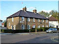
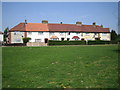
37 - 41 (odds) Henningham Road, N17
In the Tower Gardens conservation area, formerly the White Hart Lane Estate of the LCC.
Image: © Robin Webster
Taken: 11 Nov 2012
0.11 miles
6
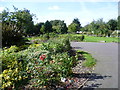
Lake, Garden of Peace, Tottenham Cemetery
Popular with water fowl.
Image: © Robin Webster
Taken: 11 Nov 2012
0.12 miles
7
The Garden of Peace in Tottenham Cemetery
Tottenham Cemetery was opened in 1858. The Garden of Peace covers about a quarter of the cemetery, the centrepiece being a sizeable lake, fed by a natural spring.
Image: © Marathon
Taken: 23 Sep 2015
0.16 miles
8
The Garden of Peace in Tottenham Cemetery
Tottenham Cemetery was opened in 1858. The Garden of Peace covers about a quarter of the cemetery, the centrepiece being a sizeable lake, fed by a natural spring.
Image: © Marathon
Taken: 23 Sep 2015
0.16 miles
9
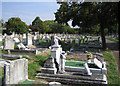
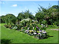
Tottenham Cemetery
The Cemetery was opened in 1858 and covers about 25 hectares, most of them in this kilometre grid square.
Image: © Nigel Cox
Taken: 6 Sep 2006
0.17 miles
10
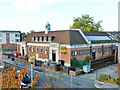
Public building for sale
Originally a library and lecture hall, with the library entrance on the left, it was later described on maps as council offices. It is now for sale described as offices, but ominously the site area is quoted.
Image: © Robin Webster
Taken: 11 Nov 2012
0.18 miles