IMAGES TAKEN NEAR TO
Greyhound Road, LONDON, N17 6XR
Introduction
This page details the photographs taken nearby to Greyhound Road, N17 6XR by members of the Geograph project.
The Geograph project started in 2005 with the aim of publishing, organising and preserving representative images for every square kilometre of Great Britain, Ireland and the Isle of Man.

There are currently over 7.5m images from over14,400 individuals and you can help contribute to the project by visiting https://www.geograph.org.uk
Image Map
Images are licensed for reuse under creativecommons.org/licenses/by-sa/2.0
Notes
- Clicking on the map will re-center to the selected point.
- The higher the marker number, the further away the image location is from the centre of the postcode.
Image Listing (62 Images Found)
Images are licensed for reuse under creativecommons.org/licenses/by-sa/2.0
Image
Details
Distance
2
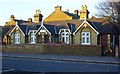
Forster Cottages, Philip Lane, South Tottenham (1860)
For more on the benefactor Josiah Forster see his entry in the Dictionary of National Biography or visit http://en.wikipedia.org/wiki/Josiah_Forster. The cottages were intended for poor widows over 55, and are now the responsibility of the Anchor Housing Trust
Image: © Jim Osley
Taken: 21 Jan 2011
0.09 miles
3
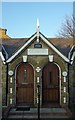
Double entrance with gable, Forster Cottages, Philip Lane, South Tottenham
With slab with the legend 18 J & R F 60 in relief.
Image: © Jim Osley
Taken: 21 Jan 2011
0.11 miles
4

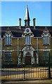
Forster Cottages, Philip Lane, South Tottenham (1860)
Image: © Jim Osley
Taken: 21 Jan 2011
0.11 miles
5

Tottenham : Grace Baptist Chapel
"benezer Strict Baptist chapel, Napier Road, traced its origins to meetings held at Welbourne hall, near the high cross, in 1884. Worshippers moved to a site in the fork between Napier and Ranelagh roads, north of Philip Lane, in 1887. Ebenezer chapel, registered there in 1898, had Sunday attendances of 65 and 93 in 1903 and seating for 300 twenty-five years later. In 1972 it was a low yellow-brick building, with red-brick decoration." - https://www.british-history.ac.uk/vch/middx/vol5/pp356-364#p37
Image: © Jim Osley
Taken: 7 Aug 2019
0.13 miles
6

High Road N17 (2)
Looking towards St Loy's Road.
Image: © Danny P Robinson
Taken: 18 Jun 2006
0.13 miles
7
Former High Cross School, Tottenham
Gothic Revival structure of 1860-62, serving variously as the Drapers College and Tottenham High School for Girls; converted to housing inn in the 1990s. The architect, Herbert Williams, was also responsible for the nearby Drapers Almshouses Image
Image: © Jim Osley
Taken: 9 Dec 2010
0.14 miles
8
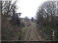
Railway to Bruce Grove
As seen from Philip Lane roadbridge.
This line leads from Seven Sisters.
Image: © David Anstiss
Taken: 3 Feb 2013
0.15 miles

10
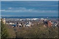
View over Wood Green and Tottenham
from the heights of Alexandra Park. A new addition to the townscape is the new ground for Tottenham Hotspur.
Image: © Jim Osley
Taken: 3 Jan 2020
0.16 miles