IMAGES TAKEN NEAR TO
High Road, LONDON, N17 6QN
Introduction
This page details the photographs taken nearby to High Road, N17 6QN by members of the Geograph project.
The Geograph project started in 2005 with the aim of publishing, organising and preserving representative images for every square kilometre of Great Britain, Ireland and the Isle of Man.

There are currently over 7.5m images from over14,400 individuals and you can help contribute to the project by visiting https://www.geograph.org.uk
Image Map
Images are licensed for reuse under creativecommons.org/licenses/by-sa/2.0
Notes
- Clicking on the map will re-center to the selected point.
- The higher the marker number, the further away the image location is from the centre of the postcode.
Image Listing (103 Images Found)
Images are licensed for reuse under creativecommons.org/licenses/by-sa/2.0
Image
Details
Distance
1
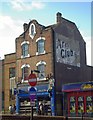
Painted wall advertisement for a cigarette brand, Tottenham
'Ghostsigns' like this are documented in such projects like http://www.ghostsigns.co.uk/
Image: © Jim Osley
Taken: 9 Dec 2010
0.01 miles
2
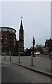
High Cross, Tottenham
High Cross is a wayside marker established in the 17th century as the centre of Tottenham https://en.wikipedia.org/wiki/Tottenham_High_Cross
Image: © David Howard
Taken: 13 Feb 2021
0.02 miles
3
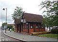
The High Cross public house, Tottenham
Micropub in A 1920s Public Toilet on High Road (A10).
Image: © JThomas
Taken: 20 Jul 2019
0.02 miles
5
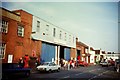
Tottenham Bus Garage
Situated in Philip Lane, N15 4JB, this bus garage was opened in July 1913, on the site of sawmills. Over the years, this garage has seen different types of buses operated including Routemasters and Leyland Atlanteans. Formerly operated by London Transport, this garage now has about 180 Arriva buses allocated, including some Hybrid vehicles. This photo was taken in September 1992, when an open day was held for the public to look round it.
Image: © David Hillas
Taken: 26 Sep 1992
0.02 miles
6
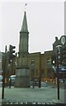
Old Wayside Cross by the A10, Tottenham High Street
Tottenham High Cross, old base in a new cross by the A10, in parish of Tottenham (Haringey District), Tottenham High Street at junction with Monument Way, on paved area in roadway; stuccoed spire.
Grade II listed.
List Entry Number: 1188856 https://historicengland.org.uk/listing/the-list/list-entry/1188856
Surveyed
Milestone Society National ID: LOHY_TOT
Image: © Milestone Society
Taken: Unknown
0.02 miles
7
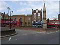
Tottenham High Cross
Tottenham High Cross stuck between the High Road and Monument Way
Image: © Shaun Ferguson
Taken: 11 May 2009
0.03 miles
8
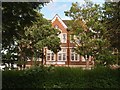
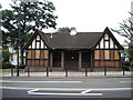
Tottenham : Tottenham Green Workshops
The workshops occupy the former Tottenham Grammar School, 1908-1910. Architect : H.G. Crothall of Middlesex County Council. Another view at Image
Image: © Jim Osley
Taken: 22 May 2020
0.03 miles
9
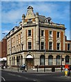
Tottenham : former bank building
Former Barclay's Bank built in 1902. Grade II listed. https://historicengland.org.uk/listing/the-list/list-entry/1079238
Image: © Jim Osley
Taken: 26 May 2020
0.03 miles
10
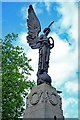
Tottenham War Memorial
"War Memorial. 1923. Bronze statue of angel representing Peace by L.F. Roslyn RBS, standing on a shaft and base of grey Cornish granite (from the Kit Hill quarry, Callington) by W. Griffiths and Sons Ltd, masons. " - Grade II listed - https://historicengland.org.uk/listing/the-list/list-entry/1061398.
Image: © Jim Osley
Taken: 25 May 2020
0.03 miles