IMAGES TAKEN NEAR TO
Clonmell Road, LONDON, N17 6JU
Introduction
This page details the photographs taken nearby to Clonmell Road, N17 6JU by members of the Geograph project.
The Geograph project started in 2005 with the aim of publishing, organising and preserving representative images for every square kilometre of Great Britain, Ireland and the Isle of Man.

There are currently over 7.5m images from over14,400 individuals and you can help contribute to the project by visiting https://www.geograph.org.uk
Image Map
Images are licensed for reuse under creativecommons.org/licenses/by-sa/2.0
Notes
- Clicking on the map will re-center to the selected point.
- The higher the marker number, the further away the image location is from the centre of the postcode.
Image Listing (45 Images Found)
Images are licensed for reuse under creativecommons.org/licenses/by-sa/2.0
Image
Details
Distance
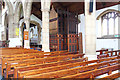
1

St Philip the Apostle, South Tottenham - Piscina & sedilia
Image: © John Salmon
Taken: 26 Apr 2013
0.16 miles
2

St Philip the Apostle, South Tottenham - West end
Image: © John Salmon
Taken: 26 Apr 2013
0.16 miles
3
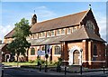
Tottenham : Church of St Philip the Apostle
Built 1906-1907 to a design by architects J.P. & J.E.K. Cutts.
Image: © Jim Osley
Taken: 25 May 2020
0.16 miles


7
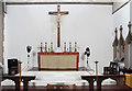
St Philip the Apostle, South Tottenham - Sanctuary
Image: © John Salmon
Taken: 26 Apr 2013
0.16 miles
8
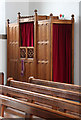
St Philip the Apostle, South Tottenham - Confessional
Image: © John Salmon
Taken: 26 Apr 2013
0.16 miles
9
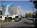
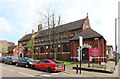
Tottenham: The Broadwater Farm Estate, N17
The estate was built between 1967 and 1973 in a style designed by Le Corbusier where no dwellings were at ground level because of the high water table of the Moselle River which is culverted under the estate. The warren of first floor concrete walkways offered opportunities for crime and anti-social behaviour and the consequent bad reputation of the estate long before the riot of 6 October 1985 which resulted in the murder of PC Keith Blakelock. Further information on the history of the estate can be found on Haringey Council's website here http://www.haringey.gov.uk/index/community_and_leisure/neighbourhoods/broadwaterfarm/historyofbroadwaterfarm.htm This is the Gloucester Road entrance to the estate. The mural on the end wall depicts a waterfall. I don't know if this is an image of an actual place or an idealized depiction of an idyllic rural scene. See Image for another photo of the estate in an adjacent grid square.
Image: © Nigel Cox
Taken: 6 Sep 2006
0.16 miles
10
St Philip the Apostle, South Tottenham - Organ
Image: © John Salmon
Taken: 26 Apr 2013
0.17 miles