IMAGES TAKEN NEAR TO
Dongola Road, LONDON, N17 6EE
Introduction
This page details the photographs taken nearby to Dongola Road, N17 6EE by members of the Geograph project.
The Geograph project started in 2005 with the aim of publishing, organising and preserving representative images for every square kilometre of Great Britain, Ireland and the Isle of Man.

There are currently over 7.5m images from over14,400 individuals and you can help contribute to the project by visiting https://www.geograph.org.uk
Image Map
Images are licensed for reuse under creativecommons.org/licenses/by-sa/2.0
Notes
- Clicking on the map will re-center to the selected point.
- The higher the marker number, the further away the image location is from the centre of the postcode.
Image Listing (53 Images Found)
Images are licensed for reuse under creativecommons.org/licenses/by-sa/2.0
Image
Details
Distance
1
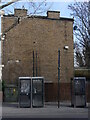
Lawrence Road London N15 Multiple Phone Boxes
Before I took the photo I checked and found all three phone boxes were still functioning. I can't imagine that even one would get enough use, if any, in this day and age in London. The boxes are not even of any historic or design significance and I wonder why they survive.
Image: © John Kingdon
Taken: 9 Feb 2023
0.14 miles
3

Tottenham : Grace Baptist Chapel
"benezer Strict Baptist chapel, Napier Road, traced its origins to meetings held at Welbourne hall, near the high cross, in 1884. Worshippers moved to a site in the fork between Napier and Ranelagh roads, north of Philip Lane, in 1887. Ebenezer chapel, registered there in 1898, had Sunday attendances of 65 and 93 in 1903 and seating for 300 twenty-five years later. In 1972 it was a low yellow-brick building, with red-brick decoration." - https://www.british-history.ac.uk/vch/middx/vol5/pp356-364#p37
Image: © Jim Osley
Taken: 7 Aug 2019
0.14 miles
4
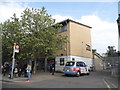
Advertising Molding on The Botany Bay pub (as was)
The Botany Bay pub (once the Greyhound) is now a supermarket with flats above. The old molded advertising board has been punctured by two central heating gas boiler vents and the remains of three light fittings hang on but cannot, and have nothing to, illuminate below them. The shadows of the neighbouring chimney pots add to the sense of decay.
Image: © John Kingdon
Taken: 31 Oct 2023
0.14 miles

6

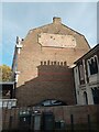
Church of St Philip the Apostle, Philip Lane, South Tottenham
Built 1906 to the designs of J.E.K. & J.P. Cutts.
Image: © Jim Osley
Taken: 21 Jan 2011
0.16 miles
7

View over Wood Green and Tottenham
from the heights of Alexandra Park. A new addition to the townscape is the new ground for Tottenham Hotspur.
Image: © Jim Osley
Taken: 3 Jan 2020
0.17 miles
8
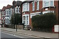
Houses on Philip Lane, South Tottenham
Image: © David Howard
Taken: 26 Jan 2022
0.17 miles
9
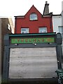
Thelma's Florist Shop Philip Lane N15
Thelma's was an independent florist's shop that has not been open since covid struck. The woman who ran it was a character but I never knew if she was the eponymous Thelma.
Image: © John Kingdon
Taken: 31 Oct 2023
0.18 miles
10
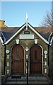
Double entrance with gable, Forster Cottages, Philip Lane, South Tottenham
With slab with the legend 18 J & R F 60 in relief.
Image: © Jim Osley
Taken: 21 Jan 2011
0.19 miles