1
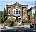
Calgary Church of God in Christ, Northumberland Park
Former Primitive Methodist chapel built in c. 1870. Brief history at this http://www.myprimitivemethodists.org.uk/page_id__2287.aspx.
Image: © Jim Osley
Taken: 17 Jul 2017
0.02 miles
2
Calvary Church of God in Christ, Tottenham Assembly
On Northumberland Park (road), N17. Originally a Methodist Chapel, registered in 1872, sold on in 1971 to the current organization. Calvary Theological College is round the back.
Image: © Robin Webster
Taken: 11 Nov 2012
0.02 miles
3
Tottenham High Road, North London
This section of Tottenham High Road, close by Tottenham Hotspur's White Hart Lane Stadium, is currently characterised by numerous blocks of empty properties, awaiting the redevelopment of the stadium and its immediate surrounding area.
Image: © Jim Osley
Taken: 9 Dec 2010
0.08 miles
4
Former Tottenham and Edmonton Dispensary
This is one of many buildings in this part of Tottenham that are closed and boarded up, perhaps to be demolished, as part of the Tottenham Hotspur football ground redevelopment project.
Image: © Jim Osley
Taken: 9 Dec 2010
0.09 miles
5
Tottenham Hotspur Football Ground from Vicarage Road, N17
Image: © John Salmon
Taken: 5 Mar 2007
0.10 miles
6
Tottenham Hotspur Football Ground from Vicarage Road, N17
Image: © John Salmon
Taken: 5 Mar 2007
0.11 miles
7
High Road Tottenham, London N17
Image: © John Salmon
Taken: 5 Mar 2007
0.12 miles
8
Tottenham : "The Coach & Horses" public house
Image: © Jim Osley
Taken: 7 Aug 2019
0.12 miles
9
The Coach & Horses (2) - sign, 862 High Road, Tottenham, London N17
The rather faded sign illustrates the pub's name.
Image
Image: © P L Chadwick
Taken: 28 Sep 2013
0.13 miles
10
The Coach & Horses (1), 862 High Road, Tottenham, London N17
This old public house is located on the corner of High Road (part of the A1010) and Brantwood Road. It dates from 1826 and was formerly a Truman house but today it is a free house owned by Woolwich Taverns.
Image
Image: © P L Chadwick
Taken: 28 Sep 2013
0.13 miles


