IMAGES TAKEN NEAR TO
Wood Mead, Grange Road, LONDON, N17 0ET
Introduction
This page details the photographs taken nearby to Wood Mead, Grange Road, N17 0ET by members of the Geograph project.
The Geograph project started in 2005 with the aim of publishing, organising and preserving representative images for every square kilometre of Great Britain, Ireland and the Isle of Man.

There are currently over 7.5m images from over14,400 individuals and you can help contribute to the project by visiting https://www.geograph.org.uk
Image Map
Images are licensed for reuse under creativecommons.org/licenses/by-sa/2.0
Notes
- Clicking on the map will re-center to the selected point.
- The higher the marker number, the further away the image location is from the centre of the postcode.
Image Listing (31 Images Found)
Images are licensed for reuse under creativecommons.org/licenses/by-sa/2.0
Image
Details
Distance
1
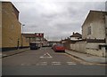
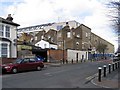
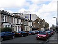
Grange Road, Edmonton
Both house extensions on the left were completed within the last year.
Image: © David Howard
Taken: 18 Feb 2018
0.09 miles
2
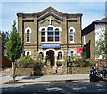
Calgary Church of God in Christ, Northumberland Park
Former Primitive Methodist chapel built in c. 1870. Brief history at this http://www.myprimitivemethodists.org.uk/page_id__2287.aspx.
Image: © Jim Osley
Taken: 17 Jul 2017
0.10 miles
3
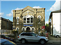
Calvary Church of God in Christ, Tottenham Assembly
On Northumberland Park (road), N17. Originally a Methodist Chapel, registered in 1872, sold on in 1971 to the current organization. Calvary Theological College is round the back.
Image: © Robin Webster
Taken: 11 Nov 2012
0.10 miles
5
Tottenham Hotspur Football Ground from Vicarage Road, N17
Image: © John Salmon
Taken: 5 Mar 2007
0.14 miles
6
Tottenham Hotspur Football Ground from Vicarage Road, N17
Image: © John Salmon
Taken: 5 Mar 2007
0.16 miles
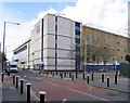
7

Tottenham High Road, North London
This section of Tottenham High Road, close by Tottenham Hotspur's White Hart Lane Stadium, is currently characterised by numerous blocks of empty properties, awaiting the redevelopment of the stadium and its immediate surrounding area.
Image: © Jim Osley
Taken: 9 Dec 2010
0.19 miles
8
Tottenham Football Ground, Park Lane, London N17
Image: © John Salmon
Taken: 5 Mar 2007
0.19 miles
9
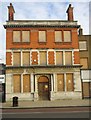
Former Tottenham and Edmonton Dispensary
This is one of many buildings in this part of Tottenham that are closed and boarded up, perhaps to be demolished, as part of the Tottenham Hotspur football ground redevelopment project.
Image: © Jim Osley
Taken: 9 Dec 2010
0.20 miles
10

North Stand, White Hart Lane Stadium, Paxton Road N17
Image: © Robin Sones
Taken: 11 Aug 2011
0.21 miles