IMAGES TAKEN NEAR TO
Hoxton Square, LONDON, N1 6NU
Introduction
This page details the photographs taken nearby to Hoxton Square, N1 6NU by members of the Geograph project.
The Geograph project started in 2005 with the aim of publishing, organising and preserving representative images for every square kilometre of Great Britain, Ireland and the Isle of Man.

There are currently over 7.5m images from over14,400 individuals and you can help contribute to the project by visiting https://www.geograph.org.uk
Image Map
Images are licensed for reuse under creativecommons.org/licenses/by-sa/2.0
Notes
- Clicking on the map will re-center to the selected point.
- The higher the marker number, the further away the image location is from the centre of the postcode.
Image Listing (535 Images Found)
Images are licensed for reuse under creativecommons.org/licenses/by-sa/2.0
Image
Details
Distance
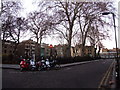
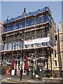
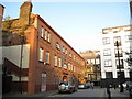
2
Hoxton Square
This short street leads off from the south western corner of the square itself to connect with Coronet Street.
Image: © Stephen McKay
Taken: 5 Mar 2008
0.02 miles
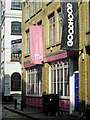
4
Hoxton Apprentice, Hoxton Square
Restaurant on the square, beside a Grade II listed church (Image).
Image: © David Anstiss
Taken: 23 May 2012
0.03 miles
5
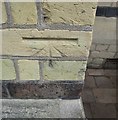
Ordnance Survey Cut Mark
This OS cut mark can be found on the front of St Monica's Church
Image: © Adrian Dust
Taken: 16 Aug 2016
0.03 miles
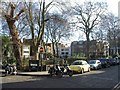
6
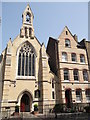
St Monica's Church, Hoxton Square
Grade II listed church on Hoxton Square.
See http://www.britishlistedbuildings.co.uk/en-436634-st-monica-s-church-hackney for more details about the church.
On the right is the Priory of the Augustinian Friars, Hackney (another Grade II listed building) converted into housing.
Image: © David Anstiss
Taken: 23 May 2012
0.03 miles
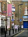
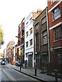
7
Coronet Street, Hoxton
Giving an indication of how these formerly run-down industrial streets surrounding Hoxton Square have revitalised in recent years.
Image: © Stephen McKay
Taken: 5 Mar 2008
0.03 miles
8
Hoxton: Former Shoreditch Electricity Generating Station & Refuse Destructor
Built in 1896 by the Shoreditch Vestry, and inaugurated in 1897 by the physicist and engineer Lord Kelvin, this was an early purpose-built undertaking designed to generate electricity from steam created by burning rubbish and dust. It was therefore an early precursor of sustainable development and recycling. The generated electricity powered street lights and some adjacent washhouses, since demolished. At its most efficient it consumed about 10 tons of rubbish per day. It was built in Coronet Street and faces onto Hoxton Market.
There is a Latin carving in the wall over the main entrance that reads
"E. Pulvere, Lux, Et, Vis."
which broadly translates into 'Light and Power from Dust’,
while over the door is another carving
"Vestry of St Leonard, Shoreditch
Electric Light Station"
The Vestry was a body responsible for local government and was a precursor of Shoreditch Borough Council.
The works was eventually decommissioned and converted in 1994 for other uses. It is currently occupied by Circus Space http://www.thecircusspace.co.uk/
Image: © Nigel Cox
Taken: 25 Sep 2008
0.04 miles
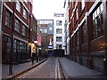
9
Hoxton: Hoxton Square, N1
This street actually leads into Hoxton Square from Coronet Street rather than being part of the square itself. Most of the buildings facing onto the square have been refurbished but the one in London stock buff brickwork with the maroon painted doors and window frames (Number 52) appears fairly original with doors opening out onto the street from the upper floors and a metal beam for a goods hoist. The street retains its cobbled surface.
Image: © Nigel Cox
Taken: 25 Sep 2008
0.04 miles