IMAGES TAKEN NEAR TO
Drysdale Street, LONDON, N1 6LS
Introduction
This page details the photographs taken nearby to Drysdale Street, N1 6LS by members of the Geograph project.
The Geograph project started in 2005 with the aim of publishing, organising and preserving representative images for every square kilometre of Great Britain, Ireland and the Isle of Man.

There are currently over 7.5m images from over14,400 individuals and you can help contribute to the project by visiting https://www.geograph.org.uk
Image Map
Images are licensed for reuse under creativecommons.org/licenses/by-sa/2.0
Notes
- Clicking on the map will re-center to the selected point.
- The higher the marker number, the further away the image location is from the centre of the postcode.
Image Listing (468 Images Found)
Images are licensed for reuse under creativecommons.org/licenses/by-sa/2.0
Image
Details
Distance
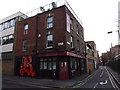
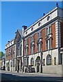
2
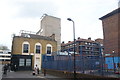
View of a former pub and flats on Drysdale Street
Looking west.
Image: © Robert Lamb
Taken: 7 May 2016
0.02 miles
3
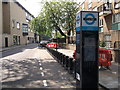
Barclays Bike Station, Hoxton Street
Almost empty bike station on the road.
Image: © David Anstiss
Taken: 23 May 2012
0.03 miles
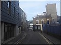
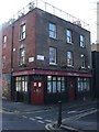
6
View of The Bridge Coffee Bar from Kingsland Road
Looking west.
Image: © Robert Lamb
Taken: 7 May 2016
0.04 miles
9
Hoxton : former Old Street Magistrates Court
Grade II listed former police station and law court. Built in the 1900s to a design by architect John Dixon Butler, architect to the Metropolitan Police. Converted to a hotel. Description at this https://historicengland.org.uk/listing/the-list/list-entry/1376533.
Image: © Jim Osley
Taken: 6 May 2020
0.05 miles
10
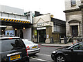
Shoreditch: Former entrance to Shoreditch station (North London Railway)
The North London Railway City Extension, from Kingsland to Broad Street, was opened in 1865, largely financed by the LNWR, who were to make major use of the new terminus. Apart from Broad Street itself, there were stations at Dalston Junction and Shoreditch, another at Haggerston being added in 1867. Shoreditch station closed in 1941 after war damage and was never re-opened, being demolished in the 1960s. Very few traces of it now remain, but this shows clearly where the Down side entrance used to be.
Image: © Dr Neil Clifton
Taken: 3 Feb 2010
0.05 miles